
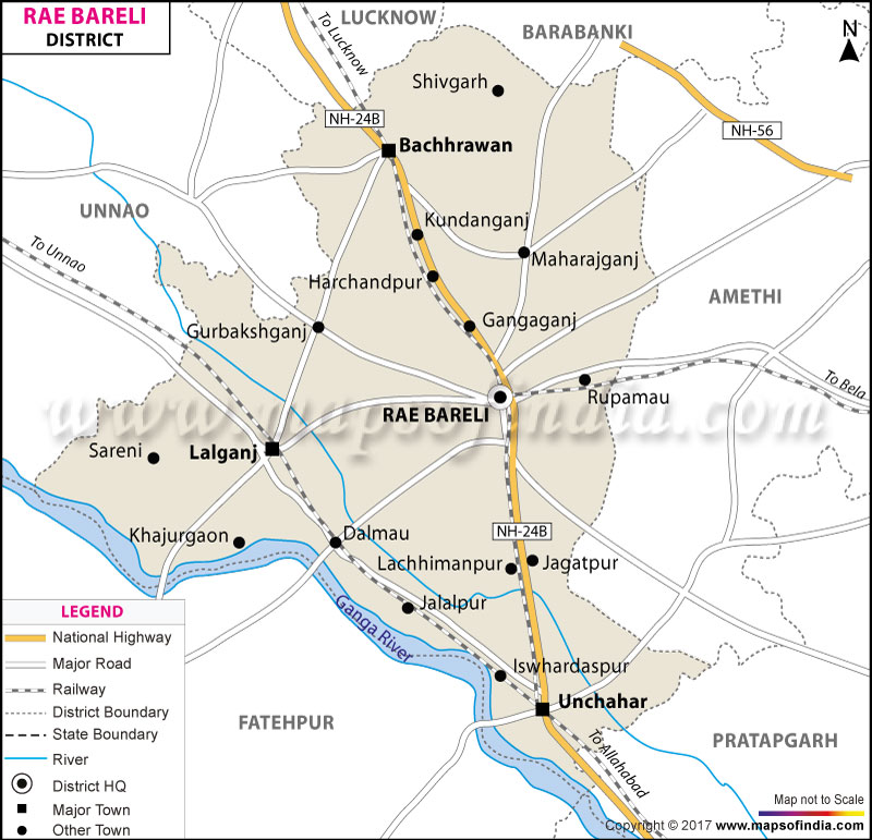
| *The Map showing the National Highway, Major roads, other Roads, District Headquarter, Town, etc in Rae Bareli District, Uttar Pradesh |
| Disclaimer: All efforts have been made to make this image accurate. However Mapping Digiworld Pvt Ltd and its directors do not own any responsibility for the correctness or authenticity of the same. |
Raebareli lies between 25°49' to 26°36'North latitudes and 100°41' to 81°34' East longitudes. It covers an area of 4,609 sq. km, and Population of Rae Bareli District in 2011 is 3404004 people.
Agriculture, animal husbandry and small scale industries mainly provide means of livelihood for the people of Raebareli.
Places to see:
A New District Namely Chhatrapati Shahuji Maharaj Nagar has been created in Uttar Pradesh which is carved out of Sultanpur and Rae Bareli districts. Gauriganj, an Assembly segment of the Amethi Lok Sabha constituency, will serve as the headquarters of Chhatrapati Shahuji Maharaj Nagar. (dated 1st July 2010)
| Facts of Rae Bareli District | |
|---|---|
| State | Uttar Pradesh |
| District | Rae Bareli |
| District HQ | Raebareli |
| Population (2011) | 3405559 |
| Growth | 18.56% |
| Sex Ratio | 943 |
| Literacy | 67.25 |
| Area (km2) | 4609 |
| Density (/km2) | 739 |
| Tehsils | Dalmau, Lalganj, Maharajganj, Rae Bareli, Unchahar |
| Lok Sabha Constituencies | Raebareli |
| Assembly Constituencies | Bachhrawan, Harchandpur, Rae Bareli, Sareni, Unchahar |
| Languages | Hindi including Awadhi |
| Rivers | Ganga, Sai |
| Lat-Long | 26.24662,81.257229 |
| Travel Destinations | Indira Gandhi Memorial Botanical Garden, Behta Bridge, Samaspur Bird Sanctuary, Lala Revti Ram Ka Talab, Saheed Smarak, Bada Kuan etc. |
| Government Colleges/Universities | Panchsheel Degree College, Feroz Gandhi Degree College, Indra Gandhi Rajkiya Mahila Degree College, Sanskrit Degree College, Gurukul Degree College, Swami Satyamitranand Degree College, Baiswara Post Graduate College, Kamla Nehru Post Graduate College, Gurukul Post Graduate College etc. |