
| Disclaimer: All efforts have been made to make this image accurate. However Mapping Digiworld Pvt Ltd and its directors do not own any responsibility for the correctness or authenticity of the same. |
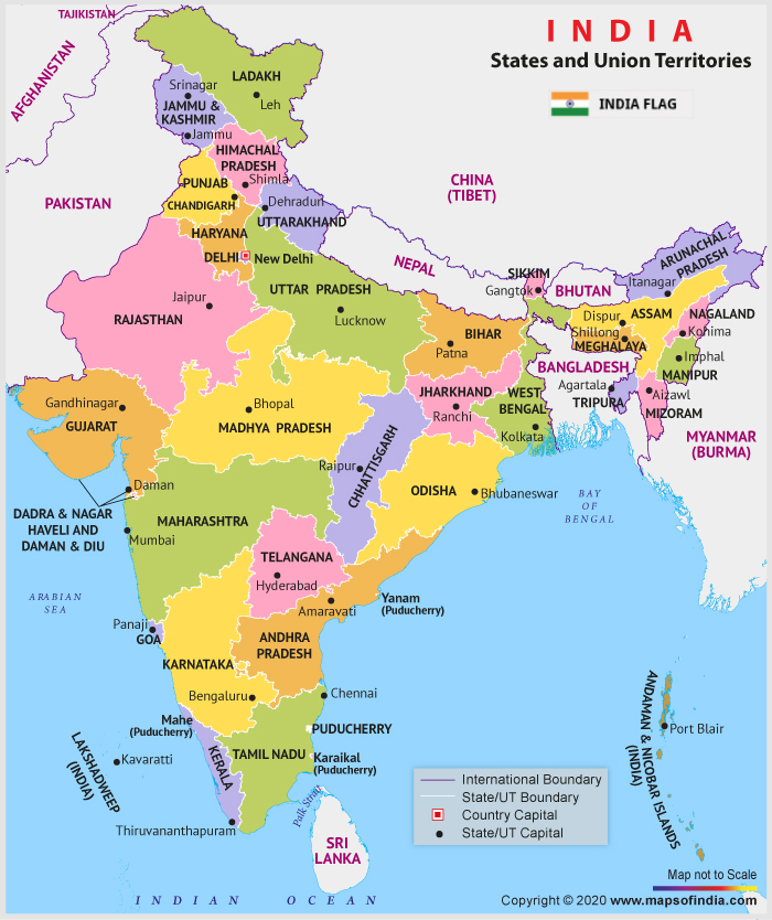
India is officially known as the Republic of India and is comprised of a total of 29 states along with seven union territories. India is the second most populated country in the world and also the world's largest democracy. The country’s coastline measures 7,517 kilometres in length, out of which a distance of 5,423 kilometres belongs to the peninsular India and 2,094 kilometres belongs to Andaman, Nicobar and Lakshadweep island chains. Additionally, the Indian naval hydrographic charts along with mainland coastline include 43% sandy beaches, 46% mudflatsor marshy shores and 11% rocky shores.
Broadly, India is divided into six major zones: East India, West India, North India, South India, Northeast India and Central India.
Eastern India includes the states of Bihar, Jharkhand, Orissa , West Bengal and a union territory Andaman and Nicobar Islands. The total population of these states is 226,925,195. The Eastern zone covers a total area of 418,323 sq km. Bengali is the dominant language in the state of West Bengal whereas Odia and Hindi are the principal languages in the states of Orissa and Jharkhand respectively. English, Maithili, Nepali and Urdu are other languages spoken in the Eastern India.
The Western region of India covers a total area of 508, 052 Sq.km. Some of the popular states of western India are Gujarat, Goa and Maharashtra with the Union Territories of Daman and Diu and Dadra and Nagar Haveli. Mumbai, the financial capital of India is the capital city of Maharashtra. The states of western India have a prosperous economy with relatively high standard of living. Official languages of the states lying in Western India include Marathi, Gujarati, Konkani and English.
The six states of North India are: Jammu and Kashmir, Himachal Pradesh, Uttar Pradesh, Uttarakhand , Punjab, Haryana with union territories of Delhi (National Capital Territory) and Chandigarh. The economy of northern India is growing at a fast pace. The most populous cities of North India are New Delhi, Jaipur, Lucknow, Indore, Patna and Chandigarh.
Southern India covers states like Tamil Nadu, Karnataka, Kerala, Andhra Pradesh, Telangana with the union territories of Lakshadweep. and Puducherry. Over 19.31% of India’s total area is occupied by these states and union territories. Bengaluru, the capital of Karnataka is known as the 'Silicon Valley of India' because it is India's leading exporter in IT sector. Most populous cities of South India include Bengaluru, Hyderabad, Chennai, Coimbatore, Cochin and Mysore.
North east India includes the seven sister states of Arunachal Pradesh, Assam , Meghalaya, Tripura, Mizoram, Manipur and Nagaland. The Himalayan state of Sikkim and Jalpaiguri Division are two important parts of northeast India. There is great ethnic and religious diversity within the seven sister states. The Central zone of India primarily refers to Madhya Pradesh and the newly formed state of Chhattisgarh.
| Andaman and Nicobar Islands | Chandigarh | Dadra Nagar Haveli and Daman Diu |
| Delhi | Jammu and Kashmir | Ladakh |
| Lakshadweep | Puducherry |