
| Disclaimer: All efforts have been made to make this image accurate. However Mapping Digiworld Pvt Ltd and its directors do not own any responsibility for the correctness or authenticity of the same. |
India is the seventh largest country in the world in terms of area. It lies on the Indian Plate, which is the northern portion of the Indo-Australian Plate. The Indian subcontinent is surrounded by three different water bodies and is easily recognisable on the world map.
The country covers an area of about 3.28 million sq. km. The mainland of India extends between 8°4' and 37°6' N latitude and 68°7' and 97°25' E longitude. The Tropic of Cancer 23°30' N divides India into almost two halves. The total length of the coastline is 7,517 kilometers. The Indian peninsula tapers southward resulting in the division of the Indian Ocean into two water bodies - the Bay of Bengal and the Arabian Sea. In India, there is a great diversity of landforms such as lofty mountains, deep valleys, extensive plains, and a number of islands.
On the basis of relief features, tectonic history and stratigraphy, India can be divided into several physical units.
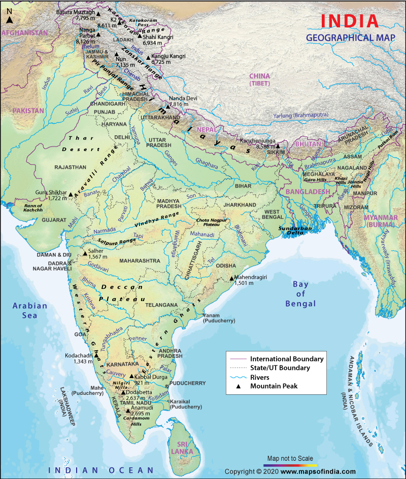
India comprises the Himalayas in the North and Northeastern region, which divides the country from the Tibetan plateau. The Himalayan range is further divided into different ranges:
Pir Panjal Range: This is the largest range of the lower Himalayas and runs from the east-southeast to west-northwest. The Pir Panjal pass lies to the west of Srinagar and comprises Banihal Pass, Sinthal Pass, Rohtang La, Munawar Pass and Haji Pir Pass.
Ladakh Range: This range extends from the northern side of Leh to the Tibetan border. It comprises Digar La Pass and Khardung La Pass. Considered a segment of the Karakoram mountain range, the Ladakh range has an extreme climate. Leh, which is the main town of the region, is regarded as a trade centre for fine pashmina wool.
Zanskar Range: This range starts from southeastern boundaries of Kashmir and extends to the eastern limit of Baltistan. Singge La Pass, Runrang La Pass, Fotu (Fatu) La Pass, Marbal Pass and Zoji La Pass are some of the passes of this range.
Dhauladhar Range: This range rises from the plains of India to the north of Mandi and Kangra. Hanuman ji Ka Tiba or the 'White Mountain' is the highest peak.
East Karakoram Range: This range separates India from Central Asia and is also one of the larger ranges of Asia. It is home to the second highest peak of the world, K2.
The Indo-Gangetic Plain is also known as Indus-Ganga and the North Indian River Plain. It is dominated by three major rivers - the Ganges, the Indus and the Brahmaputra. It covers a large area of about 7,00,000 sq. km in the Northern and Eastern India. The plain is divided into four divisions:
The Bhabhar Belt: It is a narrow belt that lies in the foothills of Himalayas and comprises pebbles and rocks brought down by the streams.
The Terai Belt: It is located next to the Bhabhar region and is made up of newer alluvium.
The Bangar Belt: It includes older alluvium and has a low upland in the Gangetic plains which is covered by the laterite deposits.
The Khadir Belt: It lies on the lowland areas after the Bangar belt and is made up of newer alluvium which is brought down by the rivers which flow down to this plain.
The Peninsular Plateau is a tableland and its characteristic features include shallow valleys and rounded hills. It is broadly divided into three different plateaus:
The Deccan Plateau: It is a triangular shaped plateau and is bounded by the Vindhyas and the Western and Eastern Ghats. It stretches across eight states of India and covers a total area of 1.9 million sq. km.
The Malwa Plateau: The Malwa Plateau is spread across parts of Gujarat, Rajasthan and Madhya Pradesh. Chambal River and its tributaries find their way in this plateau and Mahi River also flows through its Western region.
The Chota Nagpur Plateau: Situated in eastern India, Chota Nagpur Plateau covers parts of Jharkhand, Bihar, Odisha and Chhattisgarh.
The Coastal India spans Arabian Sea in the West to the Bay of Bengal in the East. The Eastern Coastal Plains lie between the Eastern Ghats and the Bay of Bengal; and stretch from Tamil Nadu to West Bengal. The rivers which flow through it are Krishna, Kaveri, Godavari and Mahanadi. It is divided into the Southern Andhra Pradesh, the Kanyakumari coast, the Mahanadi delta, the Coromondel coast and sandy coast.
The Western Coastal Plains is sandwiched between the Western Ghats and the Arabian Sea and extends from Gujarat in the north and covers the regions of Maharashtra, Goa, Kerala and Karnataka. There are numerous rivers and backwaters in this region. It is divided into two parts - the Malabar Coast and the Konkan.
The Thar Desert is one of the largest deserts of the world. It extends across Gujarat, Haryana and Punjab and covers over 60% of the geographical area of Rajasthan. It also extends to Pakistan and is known as Cholistan Desert there. Luni is the only river in this desert and it receives very little rainfall. Major portion of this desert consists of craggy rocks, sand dunes and compacted salt-lake bottoms. The speedy winds that flow with significant force lead to regular soil erosion. It has an arid climate and the vegetation is scanty.
There are two major groups of islands in India which are also classified as the union territories- the Andaman and Nicobar Islands, and the Lakshadweep Islands. Lakshadweep is located in the Arabian Sea and covers an area of 32 sq. km. It has a total of about 35 islands and islets. The Andaman and Nicobar Islands is larger in size and comprises 572 islands. Andaman is located in the north and Nicobar is located in the south. Some of the other important islands in India are Daman and Diu, Majuli, Salsette Island and Sriharikota.
The Himalayan Range: This is the world's highest mountain range and the tallest peak. Mt. Everest is also a part of this range. It acts as a barrier against the frigid katabatic winds which flow down from Central Asia and protect India from its effects.
Patkai Range: Patkai or Purvanchal lies on the east of India-Burma border. It comprises three hill ranges: Garo-Khasi-Jaintia in Meghalaya, Lushai hills and Patkai-Bum.
Karakoram Range: It lies in the disputed areas of Jammu and Kashmir and comprises more than 60 peaks. K2, the second highest peak of the world, is also a part of this range. Besides, the Hindu Kush range, Siachen and Biafo Glacier also form a part of this range.
Shivalik Hills: The literal meaning of Shivalik is 'tresses of India'. It extends from Arunachal Pradesh to West Bengal and from Uttarakhand to Kashmir and Himachal Pradesh. Jammu, Kangra and Vaishno Devi are a part of this range.
Vindhya Range: This range spreads across central India and extends across 1,050 km. It is believed to be formed from the Aravalli Mountains. Due to its geographical location in central India, it separates Northern and Southern India.
Aravalli Range: This is India's oldest mountain range and spreads across the parts of Rajasthan, Delhi and Haryana. Guru Shikhar in Mount Abu is the highest peak of this range, which rise to 1,722 m.
Satpura Range: This range stretches from Gujarat and runs to Maharashtra, Madhya Pradesh and Chhattisgarh.
Western and Eastern Ghats: Western Ghats are also known as Sahyadri Mountains and run parallel to Indian peninsula's western coast. Eastern Ghats or Purva Ghat is a discontinuous range of mountains which run along the eastern coast of India.
Spread over an area of 3,287,263 sq. km, India comprises 29 states. The largest state in India is Rajasthan. It covers an area of 3,42,239 sq. km and shares its borders with Punjab, Haryana, Uttar Pradesh, Madhya Pradesh, Gujarat and the Pakistani provinces of Punjab and Sindh.
Goa is the smallest state in India comprising an area of 3,702 sq. km. The state is located to the southwest of India. Uttar Pradesh, lying to the northeast of the country, is the most populous state. Gujarat, lying on the extreme west of the country, is one of the most prosperous of all Indian states. The strikingly beautiful Jammu and Kashmir is the northernmost state in the country. India's eastern part comprises the states of Manipur, Meghalaya, Assam, Mizoram, Nagaland, Tripura and Arunachal Pradesh. There are seven union territories in India. Delhi, the capital of India, also falls in this category. The other union territories of the country include Chandigarh in the north; Dadra and Nagar Haveli and Daman and Diu in the west; Lakshadweep in the southwest; and Puducherry and Andaman and Nicobar Islands in the southeast of the country.
India is surrounded by water from three sides - Arabian Sea in the west, Bay of Bengal in the east and Indian Ocean in the south. There are many water bodies in India in the form of rivers, canals, gulfs, backwaters, etc. There are 12 major rivers in the country and they originate from any one of the three watersheds. There is a large reserve of rivers - big and small, and all these rivers are revered in the country other than merely being the sources of water. The river Brahmaputra is a trans-boundary river. It originates in Tibet and enters India in Arunachal Pradesh. It passes through Assam before finally making its way through Bangladesh. The river Ganga is the longest river in India and is considered to be the most pious river in the country. It has several tributaries including river Yamuna, which is the only water body near the national capital - New Delhi. River Chambal, a tributary of Yamuna, passes through Madhya Pradesh, Rajasthan and Uttar Pradesh. The other major rivers in India include Narmada River, originating at Amarkantak in Madhya Pradesh; river Godavari, originating at Trayambakeshwar in Maharashtra; river Krishna, originating at Mahabaleshwar; river Kaveri, passing through Karnataka and Tamil Nadu; Mahanadi River flowing through Chhattisgarh and Odisha. The other rivers in the country include Mahi, Betwa, Penner, Kosi, Tungabhadra and several others. Gulf of Mannar, Gulf of Kutch and Gulf of Cambay are the major gulfs of the country. More...
India shares its international borders with Pakistan on its west, and Nepal, China and Bhutan on its northeast. It is surrounded by Myanmar and Bangladesh on its east. Sri Lanka lies to the south of India and the union territory Andaman and Nicobar Islands lie close to Thailand and Indonesia. The political boundaries of Pakistan and Bangladesh with India are traced according to the Radcliffe Line. The Line of Control (LoC) delineates the borders of India and Pakistan and serves as a boundary between the administered areas of Kashmir in both the countries. The MacMohan Line divides India and China and runs along the states of Arunachal Pradesh, Himachal Pradesh, Uttarakhand, Jammu and Kashmir and Sikkim. India-Bangladesh border is one of the longest borders of the world and touches the Indian states of Assam, Meghalaya, Manipur, Tripura and Arunachal Pradesh.
India has a variety of climates, varying from arid desert in the west, alpine climate in the Himalayan north to the humid tropical regions which support the island territories along with the rainforests in the southwest.
The climate is altered by the Thar Desert and the Himalayas. Some areas in the north have severe summers with extreme winters, with temperatures reaching to freezing points. The country encounters four different types of seasons - winter, summer, monsoon, and post-monsoon. In some states, the temperature in summers rise up to 45°C and minimum temperature decreases to 15°C only. In winters, the average temperature is about 10-15°C. The highest temperature recorded in India so far is 50.6°C in Alwar, Rajasthan. The lowest temperature was recorded in Kashmir at -45°C.
The map will help you locate all these and more. All the international boundaries of the country are marked in pink lines. Grey dotted lines stand for the state boundaries and will help you to get familiar with the Indian states and their neighbours. The blue lines scattered throughout the map represent all the major rivers in the country.