| *Map showing major roads, railways, rivers, national highways, etc. |
| Disclaimer: All efforts have been made to make this image accurate. However Mapping Digiworld Pvt Ltd and its directors do not own any responsibility for the correctness or authenticity of the same. |
Andhra Pradesh is a state in India, situated on the country's south eastern coast. The state is known for crafting of stones, doll-making, carving of idols, beautiful paintings, folk dances like Yaksha Ganam, Urumula Natyam, Ghato Natyam; festivals like Sankranthi, Dasara,Varalakshmi, Deepavali, Nagula Chaviti and delicacies like attu, dosas, ulavacharu and payasam.
The northern area of Andhra Pradesh is mountainous. The highest peak Mahendragiri rises 1,500 m above the sea level. The climate is generally hot and humid. Annual rainfall is 125 cm. The Krishna and Godavari are the major rivers in the state.
Andhra Pradesh has a single-chamber Legislative Assembly of 175 seats. Till date, the state sent 60 members to the Indian national parliament, 11 to the Rajya Sabha (upper house) and 25 to the Lok Sabha (lower house).
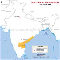
The state of Andhra Pradesh has been bifurcated and a state called Telangana has been carved out of it. The Andhra Pradesh Reorganisation Act, 2014 bill was passed in February 2014, in favour of the formation of the state of Telangana, which comprise of 10 districts from north-western Andhra Pradesh. The new state came into existence from 2 June 2014 as the 29th state of India, after the President of India's approval. Hyderabad was declared to remain the capital of both the states for ten years. However, the Andhra Pradesh government proposed a new capital for the state in Vijaywada region.
| Facts on Andhra Pradesh | |
|---|---|
| Official Website | www.ap.gov.in |
| Date of Formation | Nov 1, 1956(Organised for 1st time) June 2, 2014 (Re-organised for 2nd time) |
| Area | 1,60,200 km sq |
| Density | 308/Km2 |
| Population (2011) | 49,386,799 |
| Males Population (2011) | 24,738,068 |
| Females Population (2011) | 24,648,731 |
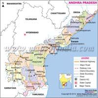
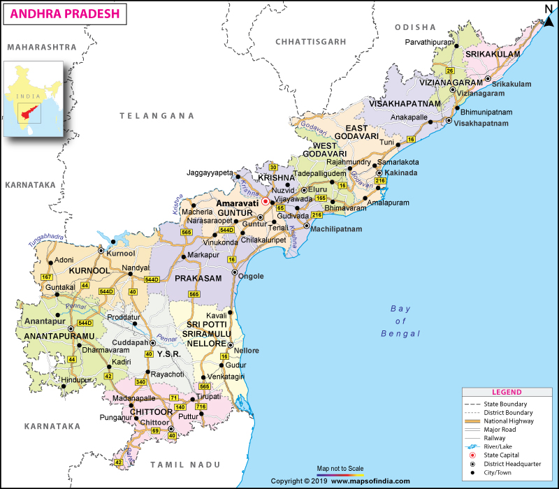
| No. of District | 13 |
| Capital | Hyderabad (Vijayawada Region is the proposed capital of Andhra Pradesh) |
| Rivers | Godavari, Krishna, Wainganga, Tungabhadra, Penner, Swarnamukhi etc. |
| Forests & National Park | Nagarjunasagar-Srisailam Wildlife Sanctuary |
| Languages | Telugu, Urdu, Hindi, English, Kannada Oriya and Tamil. |
| Neighbours State | Odisha, Chhattisgarh, Telangana, Karnataka, Yanam ( Puducherry) And Tamil nadu |
| State Animal | Blackbuck |
| State Bird | Indian Roller |
| State Tree | Neem |
| State Flower | Water lily, Nelumbo |
| Net State Domestic Product (2011) | 62912 |
| Literacy Rate (2011) | 67.41% |
| Females per 1000 males | 996 |
| Assembly constituency | 177 |
| Parliamentary constituency | 25 |
Centuries ago, Andhra Pradesh was a major Buddhist centre and part of Emperor Ashoka's sprawling kingdom. Not surprisingly, traces of early Buddhist influence are still visible in several places in and around the state. After the death of Emperor Ashoka, the Satavahanas established their kingdom in this region. During the 7th century, the Chalukyas held sway over Andhra Pradesh until the 10th century, when the Cholas seized power. In the 14th century, Muslim power reached this southern state and for centuries ruled over this princely state, and finally was taken over by a General of the Mughal Emperor Aurangzeb in 1713. Read More.....
The state is formed of two main topographic sections. The eastern part of the state is composed of the Deccan plateau and the Eastern Ghats. The northern part of the state is formed of the Telangana region, while the southern portion of the state is identified as Rayalaseema. The Rayalaseema and the Telangana region are delimited by River Krishna. The Telangana region will be formed into a separate state, post the bifurcation of Andhra Pradesh, and will be named as Telangana.Read More.....
Andhra Pradesh has 13 districts and the following table shows their respective population as per the Census 2011.
| District | Population | Male | Female |
|---|---|---|---|
| Vizianagaram | 2344474 | 1161477 | 1182997 |
| Prakasam | 3397448 | 1714764 | 1682684 |
| West Godavari | 3936966 | 1964918 | 1972048 |
| Kurnool | 4053463 | 2039227 | 2014236 |
| Srikakulam | 2703114 | 1341738 | 1361376 |
| YSR | 2882469 | 1451777 | 1430692 |
| Sri Potti Sriramulu Nellore | 2963557 | 1492974 | 1470583 |
| Visakhapatnam | 4290589 | 2138910 | 2151679 |
| Krishna | 4517398 | 2267375 | 2250023 |
As per the above data, the population of Andhra Pradesh is 4, 93, 86,799. The number of male and female population is 2, 47, 38,067 and 2, 46, 48,731 respectively. The state has a total area of 160,205 kilometer square and the density of population is 343 per square kilometer. As per the 2011 data, the total literacy rate in the districts of Andhra stands at 67 per cent.
Agriculture is the most important sector of Andhra Pradesh's economy. About 70% of the population is engaged in agriculture, and the state is one of India's main rice-producing areas. The main crops are rice, maize, millets, pulses, castor, tobacco, cotton, sugarcane, groundnut and bananas. The covered forest area in the state is about 23%, and important forest products include teak, eucalyptus, cashew, bamboo and soft wood. Some of the major industries in the state are machine tools, synthetic drugs, pharmaceuticals, heavy electrical machinery, ships, fertilizers, electronic equipment, aeronautical parts, cement and cement products, chemicals, asbestos, glass and watches. Read More.....
The bus service in the state is managed by the Andhra Pradesh State Road Transport Corporation which operates thousands of buses all over the state. The buses ply in different parts of the state including villages as there is a huge network of roads which offer feasibility and connectivity to different parts of the state. A wide railway network which offers several express and passenger trains connects the state with almost every part of the country. The airports in the state provide airlines services to domestic as well as international destinations. The government is planning to set up more airports in the state so as to improve connectivity. There are also some seaports in the state which are useful for trade and commerce.
Over 85% of the population of Andhra Pradesh speaks Telugu. Tamil is widely spoken in the extreme southern region, and on the border of Karnataka there are few Kanarese or Kannad speakers. In Hyderabad there are large numbers of Urdu speakers who make up about 7% of the state's population.
Hindu festivals such as Dasara, Deepavali, Sri Ramanavami, Krishna Janmastami, Vinayaka Chavithi (Ganesh Chaturthi) and Maha Sivarathri are celebrated in the State. Similarly, Muslim festivals such as Bakr-id and Id-ul-Fitr, and Christian festivals like Christmas, Easter and New Year's Day are also celebrated with gaiety. But the celebrations of Ugadi (Telugu New Year's day), Sankranti, Dasara, and Vinayaka Chavithi in the state are unique. Read More.....
Telugu is the official language of Andhra Pradesh which was known as 'Tenugu' in the past. Urdu is the second widely spoken and hence the co-official language of Andhra. English, Hindi, Banjara are few of the other main languages spoken in the state. Telugu is ranked as the 15th widely spoken language in the world and ranks second after Hindi in India. Influenced by the Sanskrit language, it has been declared as the classical language. Tamil, Oriya and Kannada are also spoken in some parts of the state.
Andhra Pradesh is rich in historical monuments and many holy temples. Tirupati in the Chittoor district houses one of the most famous temples in India. The presiding deity is known as Venkateswara. The main temple is situated on a hill top, Tirumala, and is a masterpiece of south Indian architecture. The main tourist attraction is the capital of the state, Hyderabad. The capital is in reality, the twin cities of Hyderabad and Secunderabad linked together by the Hussain Sagar Lake. Places of interest are the Char Minar built in 1591, Osmania University, State Museum and Art gallery, Health Museum, Public Gardens, Birla Mandir and Macca Masjid.Read More.....
There are 175 Vidhan Sabha seats and 75 members in the Vidhan Parishad in Andhra Pradesh. From Andhra Pradesh, there are 11 members in Rajya Sabha and 25 in the Lok Sabha. Presently, there are 13 districts in Andhra Pradesh. There have been several governments which ruled in Andhra Pradesh. The Indian National Congress ruled the state till 1982. N. Chandrababu Naidu is the current Chief Minister of the state. Naidu held a record for serving as the Chief Minister for the longest tenure in the state i.e., from 1995 to 2004. Neelam Sanjeeva Reddy is the first Chief Minister of the state who also became the President of India. There are many political parties like Telangana Rashtra Samithi (TRS), Telegu Desam Party (TDP), and Indian National Congress (INC) etc. but presently TDP is the ruling party in the state.
The literacy rate in Andhra Pradesh is 67.4 per cent as per the 2011 Census. There are number of government and private schools in the state. The schools in the state are either affiliated to the Central Board of Secondary Education (CBSE) or ICSE or state board. There are many higher educational institutes in Andhra including many universities and research centres. These institutions provide professional education in the fields of humanities, engineering, law, business etc. National Atomic Research Organisation and School of Planning and Architecture are major research institutions in the state which are set up by the government.
References: Census 2011 and media reports
| Sr. No. | District | District HQ | Population (2011) | Growth | Sex Ratio | Literacy | Area (km2) | Density (/km2) |
|---|---|---|---|---|---|---|---|---|
| 1 | Anantapur | Anantapur | 4081148 | 12.10% | 977 | 63.57 | 19130 | 213 |
| 2 | Chittoor | Chittoor | 4174064 | 11.43% | 997 | 71.53 | 15152 | 275 |
| 3 | East Godavari | Kakinada | 5154296 | 5.16% | 1006 | 70.99 | 10807 | 477 |
| 4 | Guntur | Guntur | 4887813 | 9.47% | 1003 | 67.4 | 11391 | 429 |
| 5 | Krishna | Machilipatnam | 4517398 | 7.87% | 992 | 73.74 | 8727 | 519 |
| 6 | Kurnool | Kurnool | 4053463 | 14.85% | 988 | 59.97 | 17658 | 229 |
| 7 | Prakasam | Ongole | 3397448 | 11.05% | 981 | 63.08 | 17626 | 192 |
| 8 | Sri Potti Sriramulu (Nellore) | Nellore | 2963557 | 11.05% | 985 | 68.9 | 13076 | 227 |
| 9 | Srikakulam | Srikakulam | 2703114 | 6.52% | 1015 | 61.74 | 5837 | 462 |
| 10 | Visakhapatnam | Visakhapatnam | 4290589 | 11.96% | 1006 | 66.91 | 11161 | 384 |
| 11 | Vizianagaram | Vizianagaram | 2344474 | 4.23% | 1019 | 58.89 | 6539 | 358 |
| 12 | West Godavari | Eluru | 3936966 | 3.51% | 1004 | 74.63 | 7742 | 508 |
| 13 | YSR | Kadapa | 2882469 | 10.79% | 985 | 67.3 | 15359 | 188 |