
| Disclaimer: All efforts have been made to make this image accurate. However Mapping Digiworld Pvt Ltd and its directors do not own any responsibility for the correctness or authenticity of the same. |
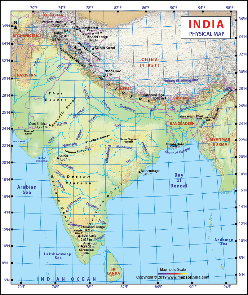
A physical map of India shows all the physical divisions of the seventh largest country in the world. The topographical features of the country are quite varied. These high quality and informative maps help you understand all the topographical features of India. The country is home to hills, deserts, forests, rivers, mountains, plateaus and seashores. There is no physical feature that you will not find in India.
A physical map of India is always a helpful guide for the students, tutors and parents. They can download this map as a printable or offline version and use it for map pointing purposes. This will help them enhance their knowledge about the physical features of India. With the help of an India physical map, you can easily locate the following areas or physiographic regions in the country:
The Himalayan Mountain Range (the highest range of mountains in the globe)
This map also highlights the prominent rivers and streams of the country such as the Yamuna, Ganga, Sutlej, Jhelum, Indus and Godavari River. The user-friendly map also has a scale which you can use to measure the elevation of the different areas throughout the nation.
A physical map of India shows all the physiographic regions of the nation. In terms of physiography, the nation can be split into the following areas:
The Himalayan Mountain ranges are home to the majority of the states of North India and Northeast India. The Great Indian Desert or Thar Desert is located in the west and forms a significant part of Rajasthan . The Indo Gangetic plain comprises the territories and provinces in the eastern and central parts of the country. The Deccan plateau forms a significant portion of the Indian peninsula in Southern India.
When you go through a physical map of India, you will notice Kanchenjungha which is the tallest peak in India and third tallest peak in the whole world. The Western Ghats mountain range and the Nilgiri mountain range have been clearly highlighted in this map. You will get to view a number of its fast moving streams like Tapti, Narmada, Godavari, Mahanadi, Kaveri, Krishna, Son, Brahmaputra, Chambal, Jamuna, and Gogra River.
You can see the Bay of Bengal, the Indian Ocean, and the Arabian Sea that edge the country from three angles on the physical map of India.
| Andaman and Nicobar Islands | Chandigarh | Dadra Nagar Haveli and Daman Diu |
| Delhi | Jammu and Kashmir | Ladakh |
| Lakshadweep | Puducherry |