
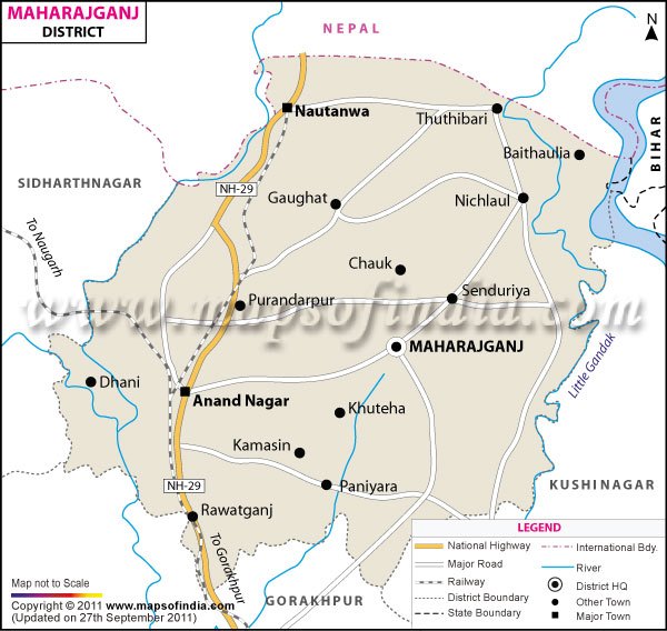
| *The Map showing the National Highway, Major roads, other Roads, District Headquarter, Town, etc in the Maharajganj District, Uttar Pradesh |
| Disclaimer: All efforts have been made to make this image accurate. However Mapping Digiworld Pvt Ltd and its directors do not own any responsibility for the correctness or authenticity of the same. |
Maharajganj District of Uttar Pradesh achieved autonomy on 2nd October 1989. This rectangular district spans from 27°09' North to 83°34' East geometric coordinates and occupies 2934.1 sq. km area. Demarcated by the Indo-Nepal border, Maharajganj is flanked by Nepal in the north, Gorakhpur District in the south, Padrauna District in the east and Siddharth Nagar and Sant Kabir Nagar Districts in west.
As per the 2011 Census, Maharajganj District has recorded a population of 26,65,292. This rural district has agrarian economy.
Maharajganj is a quaint district whose serene and tranquil environment and picturesque terrains dotted by meandering streams is a real treat. Lehara Durga Mandir is an important sightseeing destination of the district.
| Facts of Maharajganj District | |
|---|---|
| State | Uttar Pradesh |
| District | Maharajganj |
| District HQ | Maharajganj |
| Population (2011) | 2684703 |
| Growth | 23.50% |
| Sex Ratio | 943 |
| Literacy | 62.76 |
| Area (km�) | 2953 |
| Density (/km�) | 903 |
| Tehsils | Maharajganj Sadar, Nautanwa, Nichlaul, Pharenda |
| Lok Sabha Constituencies | Maharajganj |
| Assembly Constituencies | 5-Maharajganj, Nautanwa, Paniyara, Pharenda, Siswa |
| Languages | Hindi, Bhojpuri, Urdu |
| Rivers | Gandak |
| Lat-Long | 27.112923,83.503933 |
| Travel Destinations | Lehara Durga Mandir, The Sohagi Barwa Wildlife Sanctuary etc. |
| Government Colleges/Universities | Rajiv Gandhi Degree College, Akshaiber Singh Memorial Post-Graduate College, Dr. Ram Manohar Lohia Mahavidyalya, Paramhans Pal Mahavidyalya, Lt. Bhagwant Ptael Panmati Devi Mahavidyalya, Jawaharlal Nehru Smarak P.G. College, Swarn Prabha Mahila Mahavidyalaya Etc., Swarn Prabha Mahila Mahavidhyalya etc. |