
| Disclaimer: All efforts have been made to make this image accurate. However Mapping Digiworld Pvt Ltd and its directors do not own any responsibility for the correctness or authenticity of the same. |
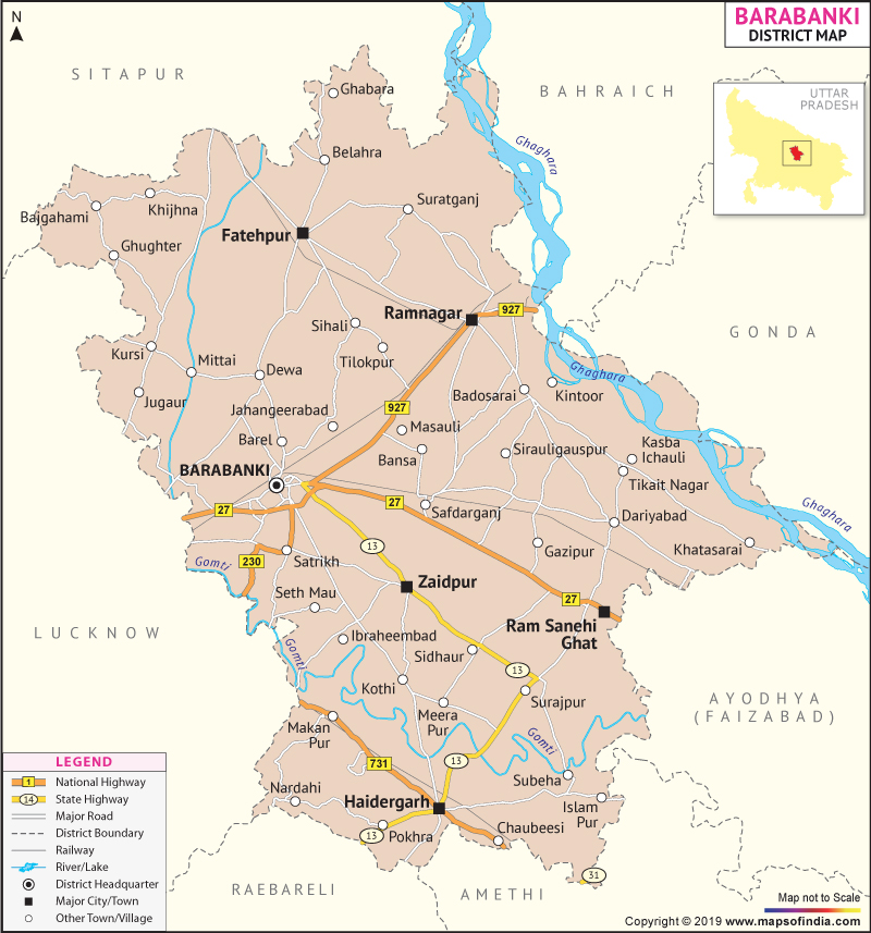
Barabanki stretches from 26°30' and 27°19' North Latitudes and 80° 58'and 81°55' East Longitudes. Occupying an area of 3895.4 sq. km, the district is home to 30, 60,990 people as per Census 2001.
Agriculture, bio-gas plants, animal husbandry, small-scale industries provide direct and indirect employment to the people of Barabanki.
Tourist places:
| Facts of Barabanki District | |
|---|---|
| State | Uttar Pradesh |
| District | Barabanki |
| District HQ | Barabanki |
| Population (2011) | 3260699 |
| Growth | 21.96% |
| Sex Ratio | 910 |
| Literacy | 61.75 |
| Area (km2) | 3825 |
| Density (/km2) | 739 |
| Tehsils | Fatehpur, Haidergarh, Nawabganj, Ramnagar, Ramsanehighat, Sirauli Gauspur |
| Lok Sabha Constituencies | Barabanki, Faizabad (partial) |
| Assembly Constituencies | Barabanki, Dariyabad, Haidergarh, Kursi, Ram Nagar, Rudauli, Zaidpur |
| Languages | Hindi, Urdu, Awadhi |
| Rivers | Ghaghara, Gomti, Kalyani |
| Lat-Long | 27.000408,81.248589 |
| Travel Destinations | The Barabanki Ghantaghar, The Mahadeva Temple, Kunteshwar Temple, Mausoleum Of Sufi Saint Qazi Qutub etc. |
| Government Colleges/Universities | Sant Kavi Baba Baijnath Govt. P.G. College, Ganga Devi Lal Bahudur Degree College, Jawaharlal Nehru Memorial Post-Graduate Degree College, Munsi Raghunandan Prasad Sardar Patel Mahila Degree College, Pioneer Degree College, Ram Sewak Yadav Degree College, Rudauli Degree College, Sai P.G.College, Sahyogi Rb Degree College, Ideal Degree College etc. |