
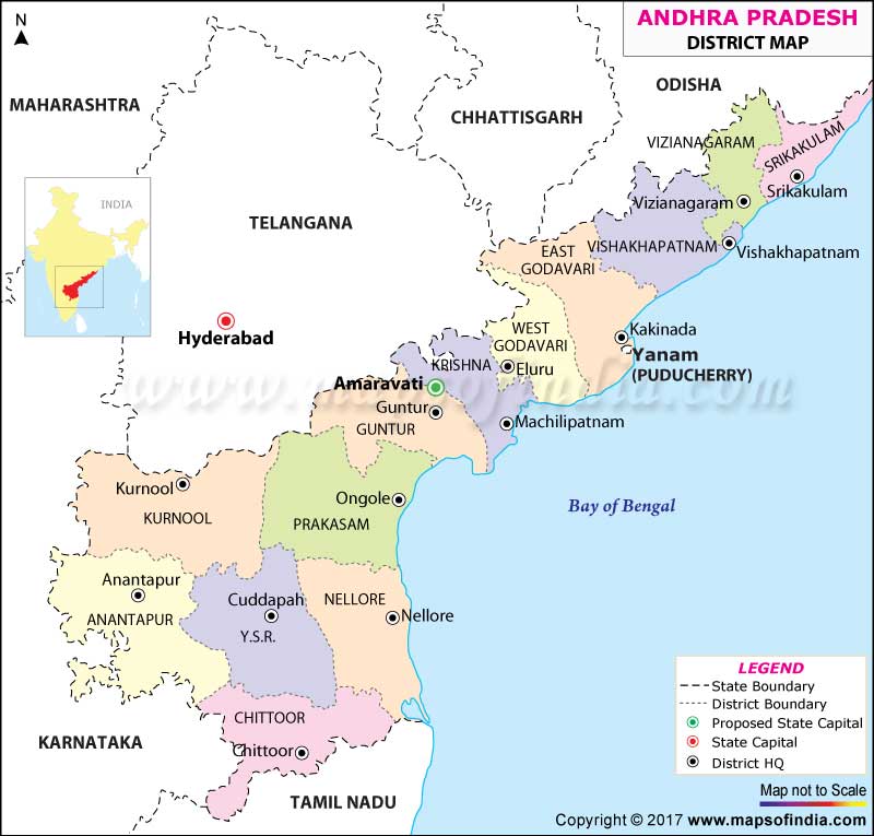
| *Map provides the information of Andhra Pradesh Districts, Location of Districts and Headquaters. |
| Disclaimer: All efforts have been made to make this image accurate. However Mapping Digiworld Pvt Ltd and its directors do not own any responsibility for the correctness or authenticity of the same. |
Andhra Pradesh is one of India's Southern states situated on the coastline of Bay of Bengal. Ranked highest among the rice producing states of India, Andhra Pradesh is nicknamed as Rice Bowl of India. With an area of 162,970 square kilometres it is the eighth largest state of India by size and with 49,386,799 inhabitants, it is the tenth largest state by population.
Hyderabad was the capital city of Andhra Pradesh, but with bifurcation of Telangana, the city will now serve as capital of the new state. Andhra Pradesh will function from Hyderabad till 2024 and Amaravati is being developed to take over as Andhra's Capital.
The population of Andhra Pradesh before the formation of Telangana as a separate state was 84,655,533 (2011 census) and it then covered an area of 275,045 sq km. But now, the state is spread across 160,205 sq km and has a population of 49,378,776. Its neighbouring states are Tamil Nadu, Karnataka, Telangana, Chhattisgarh and Odisha.
Andhra Pradesh is famous for its delicious Andhra cuisine - tangy, hot and spicy. Red chilli is produced in abundance here and is a favourite among the locals.
Andhra Pradesh has a total number of twenty three districts and is divided into two regions:
These regions have been subdivided into districts. Each district is governed by a District Magistrate, an official from the Indian Administrative Service, who is in charge of administration and revenue collection. A Superintendent of Police, on officer from the Indian Police Service, is in charge of maintaining law and order in the district and a Deputy Conservator of Forests, an officer from the Indian Forest Service, who is in charge of forests, environment and wildlife.
Andhra Pradesh is blessed with natural beauty and many tourist attractions. Popular tourist centres in Andhra Pradesh are Visakhapatnam- the beach city, Chittoor- Horsley Hills, Kurnool - Mahanandishwara temple, Rajamundri and Prashanti Nilayam -Puttaparthi, Tirupati Balaji Temple at Tirupati, the churches and temples of Vijaywada, and the temples of Nellore. A scenic destination in Vishakapatnam, the Araku valley is a perfect tourist destination. Srisailam is a popular pilgrimage centre, while Leepakshi is a historical heritage site from the 16th century. Leepakshi handicrafts are very famous. Papikondalu and Rajahmundry have a lake and backwaters. Talakona waterfalls enchant with their scenic beauty and are famous for their herbs with healing powers. The area is often visited by trekkers.
| S No. | District | Headquarters | Population (Census 2011) | Sex Ratio (per 1000) | Average Literacy |
|---|---|---|---|---|---|
| 1 | Anantapur | Anantapur | 4081148 | 977 | 63.57% |
| 2 | Chittoor | Chittoor | 4174064 | 997 | 71.53% |
| 3 | East Godavari | Kakinada | 5154296 | 1006 | 70.99% |
| 4 | Guntur | Guntur | 4887813 | 1003 | 67.40% |
| 5 | Krishna | Machilipatnam | 4517398 | 992 | 73.74% |
| 6 | Kurnool | Kurnool | 4053463 | 988 | 59.97% |
| 7 | Prakasam | Ongole | 3397448 | 981 | 63.08% |
| 8 | Sri Potti Sriramulu Nellore | Nellore | 2963557 | 985 | 68.90% |
| 9 | Srikakulam | Srikakulam | 2703114 | 1015 | 61.74% |
| 10 | Visakhapatnam | Visakhapatnam | 4290589 | 1006 | 66.91% |
| 11 | Vizianagaram | Vizianagaram | 2344474 | 1019 | 58.89% |
| 12 | West Godavari | Eluru | 3936966 | 1004 | 74.63% |
| 13 | YSR (Kadapa) | Kadapa | 2882469 | 985 | 67.30% |