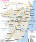
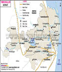
| *The Map showing the National Highway, Major roads, District Headquarter, Town, etc in the Madurai District, Tamil Nadu |
| Disclaimer: All efforts have been made to make this image accurate. However Mapping Digiworld Pvt Ltd and its directors do not own any responsibility for the correctness or authenticity of the same. |
Madurai district lies in the South of Tamil Nadu state, bordered by the districts of Dindigul, Thiruchirapalli on the North and by Sivagangai on the East and by Theni on the West and by Virudhunagar on the South. It is geographically located between 930'' and 1030'' North Latitude and between 770.00 and 7830.00 East Latitude.
It covers an area of 3741.73 Sq. km. With the total population of 25,62,279 (2001 Census) comprising of 12,95,124 males and 12,76,155 females. The economy of Madurai district is chiefly agrarian. The two other sectors that contribute significantly to the local economy are textiles and tourism.
Famous tourist places in Madurai district are:
| Sri Meenakshi Temple | Thirupparankundram Temple | Mariamman Teppakulam |
| Gandhi Museum | Thirumalai Nayak Palace | Mariamman Teppakulam |