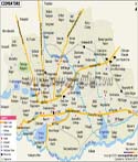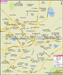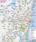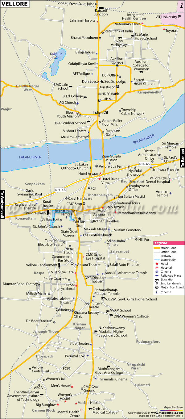
| Vellore city Map showing roads, hotels, hospitals and other places of interest. |
| Disclaimer: All efforts have been made to make this image accurate. However Mapping Digiworld Pvt Ltd and its directors do not own any responsibility for the correctness or authenticity of the same. |
Located on the banks of river Palar, Vellore is a city and an administrative headquarters in Tamil Nadu. The city enjoys the privilege of being the seat of different empires such as the Cholas, the Pallavas, the Nayaks, the Marathas, the Arcot Nawabs and Bijapur Sultan Kings. The city is famous for the historic fort which was built in the 13th century and is an embodiment of grandeur. It was considered to be one of the strongest fortresses during the Carnatic wars that were fought in the 18th century. Geographically, the city is located at 12° 15' to 13° 15' North latitudes and 78° 20' to 79° 50' East longitudes. The Vellore district covers an area of 6,077 sq km. Palar and Ponnai are the two major rivers of the district.
The economy of the city gets major contributions from the tertiary sectors. Agriculture, leather industry and the industries which are in and around the city are the providers of employment in the district. Vellore district is the largest exporter of finished leather goods in India and constitutes about 37% of the total export of the country. There are many well-known industries and organisations in the city such as Bharat Heavy Electricals Limited (BHEL), EIDD Parry and Kramski Stamping and Molding India Pvt. Ltd. to name a few.
It is home to many prominent technological and medical institutes. Besides a government university, there is a private technological university, several colleges offering courses in humanities and science and a government and a medical school. Christian Medical College & Hospital (CMCH) is one of the largest hospitals not only in the country but Asia as well and offers health care services to the neighbouring areas. Most of the colleges in Vellore and its nearby districts are affiliated to Thiruvalluvar University. There are Arabic colleges also in the city like Madrasa Al-Baqiyathus Salihath founded by Maulana Shah Abdul Wahab.
Vellore is well-equipped in terms of transportation facilities. National Highways - NH 46, NH 234 and NH 4 pass through the city. There is also a bus service available in the city which connects it to several other cities of Tamil Nadu, Andhra Pradesh and Karnataka, such as Bangalore, Chennai, Tirupati, Trichy, Kalpakkam, Nagercoil and many more. There are three main railway stations in the city- Vellore Cantonment, Vellore Town and Katpadi Junction. Express trains pass daily from these junctions and connect the city to other cities of India. Chennai International Airport and Bengaluru International Airport are the nearest airports to the city. There is an airport near Abdullahpuram, but it was only used for providing aeronautical trainings and is not open to the public.
It has a lot to offer in terms of tourism. Vellore Fort is a prominent landmark in the city. It houses a temple, a mosque and a church and is known for its carvings. Yelagiri Hills, located near Vellore has beautiful hill resorts and offers picturesque scenes of nature. Jalakandeswarar Temple, Wallajapet Dhanvantri Temple, Srilakshmi Golden Temple and Rantnagiri Murugan Temple are some of the prominent Hindu temples in the city which attract many visitors.