
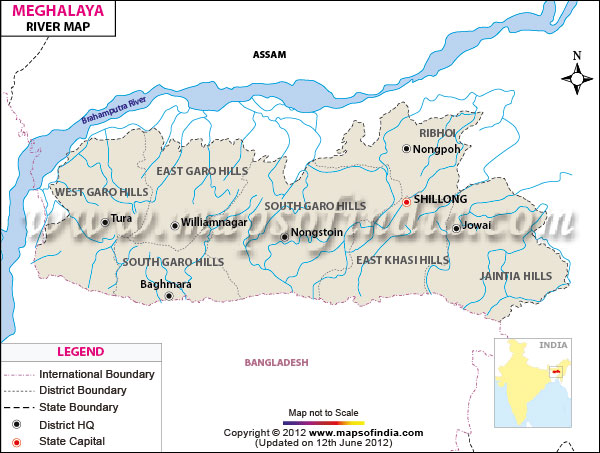
| *The Meghalaya Rivers Network Map showing the River Flowing in and out of Meghalaya state. |
| Disclaimer: All efforts have been made to make this image accurate. However Mapping Digiworld Pvt Ltd and its directors do not own any responsibility for the correctness or authenticity of the same. |
The Indian state of Meghalaya has many rivers making them an intrinsic component of the state. The majority of these rivers are rain fed, thus making them seasonal. The rivers have formed deep canyons and numerous glistering waterfalls in the state.
The important rivers of Meghalaya that shape the northern region and course from west to east are the Ajagar, Chagua, Kalu, Didram, Dudnai, Krishnai and Ringgi and the important rivers that shape the southern region are Daring, Bhogai, Sanda, Dareng, Simsang, Bandra, Nitai and Bhupai.
Similarly, the important rivers of the central and eastern regions of Meghalaya that course towards the north are Umkhri, Umiam and Digaru and some main rivers of the eastern regions that course towards south are Barapani, Kynchiang, Mawpa, Myngot and Myntdu.
Some other important rivers of Meghalaya are:
| River Map of East Garo Hills | River Map of East Khasi Hills | River Map of Jaintia Hills |
| River Map of Ribhoi | River Map of South Garo Hills | River Map of West Garo Hills |
| River Map of West Khasi Hills |