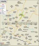
.gif)
| *The Map showing Roads, Railway, Hotels, Hospitals and Important Landmarks of Shillong, Meghalaya. |
| Disclaimer: All efforts have been made to make this image accurate. However Mapping Digiworld Pvt Ltd and its directors do not own any responsibility for the correctness or authenticity of the same. |
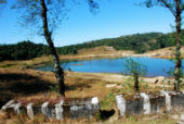
Shillong, capital of the state of Meghalaya is located at 25.57° N and 91.88° E on a plateau in the eastern part of the state. Shillong falls in the East Khasi hills district of the state and is also the district headquarters. The city, spread over a total area of 6436 square kilometers, is situated at an altitude of 1496 meters, surrounded by hills. The temperature varies from 23°C in summers to 4°C in winters.
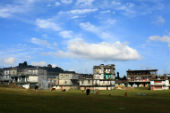
The temperate hill climate and the natural beauty of the country side have made Shillong into an attractive tourist destination of the state and the city offers all the facilities for tourists such as hotels and accommodation. It is one of the few urban centers in the state.
Roads are the most important link of the city and it is connected by motorable roads to neighboring states and the country. There is no airport in the city, nor is it connected by rail. The closest air and rail link is in Guwahati in Assam. Shillong is connected by National highway 40 and National highway 44. NH 40, runs entirely within the state of Meghalaya and connects Shillong to Jorabat and Jowai. NH 44 connects Shillong with Agartala, the capital of Tripura, passing through the state of Assam at Karimganj.
The total population of the city is 223366 with the majority of the populations belonging to the Khasi tribe. Christianity is the dominant religion and Shillong has a number of churches. It also has a very high literacy rate of 87%.
Shillong is divided into various geographical localities having schools, churches, hospitals etc. The localities are Langkryding, Pynthorumkhrah, Shyriap, Laitumkhrah, Happy Valley, Dernthring, Nongthymmai, Moti nagar, Lamwabah, Upper Mawprem, and Lower Mawprem. Laitumkhrah has one of the oldest hospitals in Shillong, The Nazareth Hospital. The Laitumkhrah Catholic Cemetery is also located here. The church of Saint Peters and Paul is located in Pynthorumkhrah.
Some of the famous churches in Shillong are Baptist church, Catholic Pastoral center, All Saints Church, St Peters and Paul Catholic church, Mawpat Catholic Church, Mawlai Kyntonmasar Presbyterian Church.
Shillong is one of the most developed parts of the state and has developed into an educational hub with a number of educational institutes present here The educational institutes in the city are Auxillium School, , Seng Khasi Higher secondary School, Lady Keane College, Army school, Queenie Secondary School, Shillong Vidyalaya, Shillong Polytechnic ,North Eastern Hill University, and CMJ University.