
Meghalaya has a total number of Seven Districts. Each district is further divided into sub-divisions and blocks. The Deputy Commissioner is the head of each district.
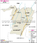
East Garo Hills district - (Area - 2603 km2, Population - 317,618) Its headquarters is Williamnagar. It is divided in 5 administrative division blocks. It houses the Nokrek National Park.
East Khasi Hills district - (Area - 2752 km2, Population - 824,059) Its headquarters is Shillong and is the most populated district. It is divided in 8 administrative division blocks.
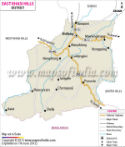
Jaintia Hills district - (Area - 3819 km2, Population - 392,852) Its headquarters is Jowai and the district possesses charming natural beauty. It is divided in 5 administrative division blocks.
Ri-Bhoi district - (Area - 2378 km2, Population - 258,380) Its headquarters is Nongpoh. It is divided in 3 administrative division blocks and is the second least populated district.
South Garo Hills district - (Area - 1850 km2, Population - 142,574) Its headquarters is Baghmara It is divided in 4 administrative division blocks and is the least populated district.
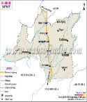
West Garo Hills district - (Area - 3714 km2, Population - 642,923) Its headquarters is Tura. It is divided in 8 administrative division blocks and is the second most populated district.
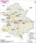
West Khasi Hills district - (Area - 5247 km2, Population - 385,601) Its headquarters is Nongstoin. . It is divided in 6 administrative division blocks and houses the Langshiang Falls, the third highest falls in India.
| Sr. No. | District | District HQ | Population (2011) | Growth | Sex Ratio | Literacy | Area (km2) | Density (/km2) |
|---|---|---|---|---|---|---|---|---|
| 1 | East Garo Hills | Williamnagar | 317917 | 0.2687 | 972 | 73.95 | 2603 | 121 |
| 2 | West Garo Hills | Tura | 643291 | 0.2409 | 984 | 67.58 | 3714 | 173 |
| 3 | North Garo Hills | Resubelpara | * | * | * | * | * | * |
| 4 | South Garo Hills | Baghmara | 142334 | 0.4095 | 945 | 71.72 | 1850 | 77 |
| 5 | South West Garo Hills | Ampati | * | * | * | * | * | * |
| 6 | East Jaintia Hills | Khliehriat | * | * | * | * | * | * |
| 7 | West Jaintia Hills | Jowai | 395124 | 0.321 | 1013 | 61.64 | 3819 | 103 |
| 8 | East Khasi Hills | Shillong | 825922 | 0.2496 | 1011 | 84.15 | 2752 | 292 |
| 9 | South West Khasi Hills | Mawkyrwat | * | * | * | * | * | * |
| 10 | West Khasi Hills | Nongstoin | 383461 | 0.2953 | 980 | 77.87 | 5247 | 73 |
| 11 | Ri-Bhoi | Nongpoh | 258840 | 0.3426 | 953 | 75.67 | 2378 | 109 |