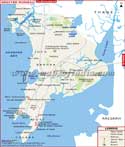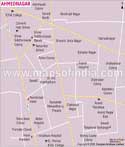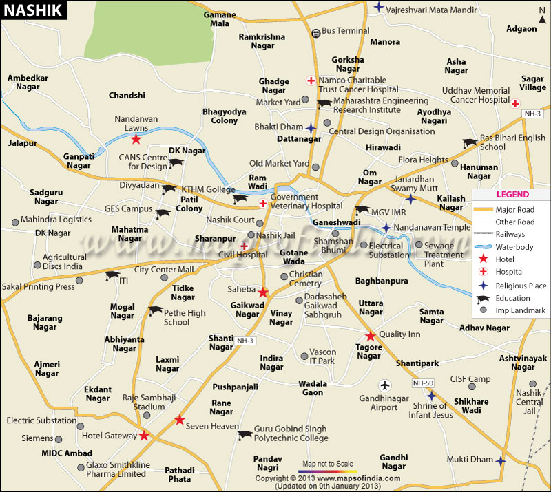
| *Nashik city Map showing roads, hotels, hospitals and other places of interest. |
| Disclaimer: All efforts have been made to make this image accurate. However Mapping Digiworld Pvt Ltd and its directors do not own any responsibility for the correctness or authenticity of the same. |
Nasik, which is also spelled and pronounced as Nashik, is a city in northwest Maharashtra, India. It is located at a distance of about 160 km from Mumbai and 210 km from Pune.
The city is the administrative headquarters of Nasik district and has been nicknamed as the "Wine Capital of India". The Nasik city has a total area of 264.23 sq km. It is the third most industrialized city in Maharashtra after Mumbai and Pune. The city is situated at an elevation of 600m and the River Godavari flows through various parts of the city.
The city is the third largest urban area of Maharashtra after Mumbai Metropolitan Region and the Pune. The city has a semi-arid climate with hot summers from March to mid-June, Monsoon Season from June to September and mild, dry winters from November to February. Occasional cold waves can dip temperatures. However increase in temperature and decrease in rainfall is noticed in recent years due to industrialization and hasty deforestation. The city is however a better city to live in as it is one of the least polluted cities in Maharashtra.
As per the 2011 Census of India, Nasik has a population of 14,86,973 inhabitants. Out of which 54% are Males and 46% are females. The city has an average literacy rate of 74%. Over the years, Nasik has grown both in population and area, so the nearby villages and towns have been included in the Nasik Urban Agglomeration. The names of these places are: Deolali Cantonment, Nasik Road, Eklahare, Mhasrul, Pimpalgaon Bahula, Adgaon, Makhmalabad, Upnagar and Someshwar.
Nasik has notable structures of historical importance scattered all over. The city is a famous religious destination for Hindus in India. It hosts one of the largest religious gatherings in the world known as the Kumbh Mela. It is celebrated once in twelve years. There are many temples in Nasik that the devotees and tourist would like to visit, There are plenty other tourist attractions and important places to see in Nasik. The Pandavleni Caves, Museum of Numismatics, Dudhsagar Fall, etc are some of the popular places in Nasik.
Nasik is well linked with National Highway Number 3 to Mumbai and National Highway Number 50. These two major highways are connected with other roads in the city. The city is well connected with other states and cities by numerous state highways. The Maharashtra State Road Transport Corporation and private bus operators operates regular bus services to various villages, towns and cities around Nasik. Taxi and cab services are also easily available in the city.
The Nasik Road Railway Station is about 11 km from the city center. Commuters can reach Nasik easily from major cities in the state and country. Daily Intercity Superfast Express Trains connects Mumbai with Nasik. There are two airports in Nasik. The Ghandinagar Airport is a Flying school but handles domestic flights and the Ozar Airport is a defence airport with no commercial flight authorization.