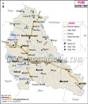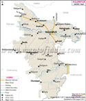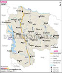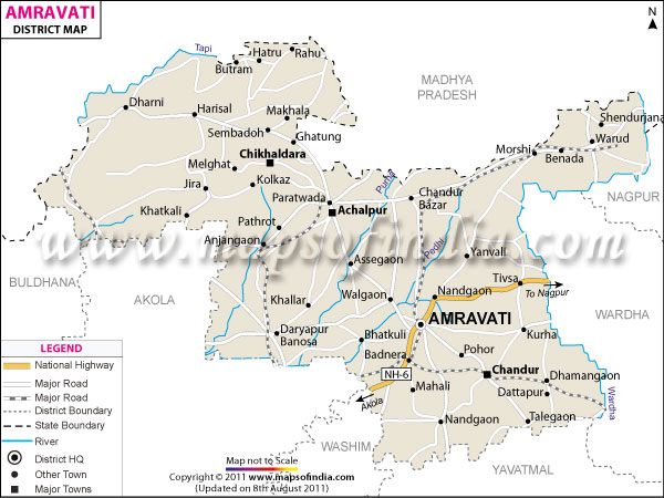
| *Amravati District map showing National highways, district headquarter, roads, towns etc. |
| Disclaimer: All efforts have been made to make this image accurate. However Mapping Digiworld Pvt Ltd and its directors do not own any responsibility for the correctness or authenticity of the same. |
Amravati is a district in the state of Maharashtra in India. Located in the central part of the country, it is a well-known tourist spot and also a major commercial and trading hub.
The administrative headquarters of the district is located in the town of Amravati. The Amravati district map helps travelers to get useful information about various features of the district.
Geographic Location of Amravati:
Situated at 20.30 to 21.50 degree of Latitude from the north and 76.35 to 78.27 North degree of Longitude from the east, Amravati district has an area of around 12,210 sq km. It is surrounded by the districts of Betul, Nagpur and Wardha, Yavatmal, Washim, Akola and Buldhana. The Wardha River flows through the eastern part of the district. The area of the irrigated land in hectors is about 6.38 lakh and the forest area stretches up to 3.88 lakh Hectors.
Major towns of Amravati:
Achalpur, Anjangaon Surji, Chikaldara, Warud, Morshi, Shendurjana Ghat, Chandurbazar, Paratwada, Daryapur, Nandgaon Khandeshwar, Badnera, Dharni
History of Amravati:
Historicall called 'Udumbravati', the name Amravati is said to have emerged from the ancient Ambadevi temple situated in the district. Amravati is an ancient city established in 1097. It is believed that in the 14th century Amravati district faced a famine because of which the people in Amravati migrated to Gujarat and Malwa. Amravati was modernized when it came under the British rule.
In the year 1903, Amravati became a part of the Central Provinces and Berar. After independence, in the year 1956, Amravati district became yet another Mumbai state. Later after its partition in the year 1960 it became an independent district of Maharashtra.
Climatic Condition of Amravati:
Amravati district in Maharashtra experiences a tropical climate with hot and humid summers and cool and dry winters. The ideal time for visiting Amravati is between the months of October and March. The weather at this time of the year remains fine.
Languages spoken in Amravati:
Marathi, Hindi, Urdu and English happen to the primary spoken dialects.
Demographics of Amravati:
As per 2001 census the population of Amravati is 2,607,160. Female population is about 85.96 lakh whereas the male population is about 91.19 lakh.
Time Zone:
Amravati follows Asia/Kolkata time zone id.
Education in Amravati:
1. Engineering Colleges
2. Medical Colleges
3. Other Colleges
River and tributaries in Amravati:
Take a look at the rivers and tributaries which flow through the district:
Tourist Attractions in Amravati:
There are numbers of tourist attractions in Amravati. The Amravati district map helps travelers by proving the location of these tourist spots. Lots of sightseeing tours are also offered by the local tourist board and other agencies. Some places which are mostly frequented by tourists are:
In addition, travelers can opt for excursion trips as well to places such as:
There are plenty of lodging centers and hotels in Amravati district which offer good facilities. Most hotels are in the vicinity of the main town center of Amravati and are easily accessible.
Getting to Amravati:
By referring to the Amravati district map, travelers can get an idea of the various routes available for reaching Amravati. The nearest airport is located in the city of Nagpur. Amravati is also a major station in the Central Railway line and is linked with places like Bhusawal, Wardha, Pune, Dhulghat, and Achalpur and so on. Road network is also developed.