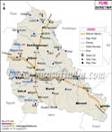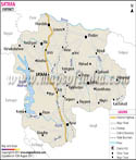
| *Latur District Map highlights the National Highways, Major Roads, District Headquarter, etc in Latur. |
| Disclaimer: All efforts have been made to make this image accurate. However Mapping Digiworld Pvt Ltd and its directors do not own any responsibility for the correctness or authenticity of the same. |
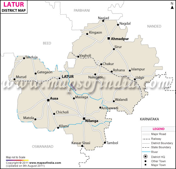
Latur District is situated in the south-eastern part of the Maharashtra. It lies at the border of Maharashtra and Karnataka. Latur faced a mass destruction in the year 1993 due to a devastating earthquake.
Geographic Location of Latur:
Lotur is located at latitude 18.05 TO 18.07 north and longitude 73.25 To 77.25 east.
Surrounded by Parbhani district in the north, Osmanabad district in the west and south, Bidar district in the east, Nanded district in the north-east and Beed district in the north-west, Latur is the southernmost district of Maharashtra.
Lying on the banks of Panchganga River, the ancient city of Latur is the administrative center of the district. Latur District Map is helpful for the tourists heading to Latur.
History of Latur:
Latur is an ancient city. Its historic name is Ratnapur. Latur city was built by the King Amoghvarsha belonging to the Rashtrakutas dynasty. The Rashtrakutas considered themselves as the citizens of Lattalut.
Prior to1981, Latur belonged to Osmanabad district. In 1981, Latur was declared as an independent district. Today Latur is one of the fastest growing cities of Maharashtra.
Climatic Condition of Latur:
Latur experiences a moderate temperature. Temperature ranges from 39.6 °C to 28°C during the summers in the winters the temperatures lies between 34°C to 13.9°C. annual rainfall in Latur ranges from 600 to 800 mm.
Rivers and Tributaries in Latur:
Following are the rivers and tributaries that flow through Latur:
Demographics of Latur:
The district of Latur has a population of around 2,080,285 (2001 India census).
Language spoken in Latur:
Marathi is the official language of the district.
Economy of Latur:
Agriculture is the chief source of income in Latur. The main crops produced here are pulses, cereals, oilseeds and grapes.
Education in Latur:
Tourist Attractions in Latur:
Some of the popular places of interests in Latur include:
Apart from the above-mentioned destinations, travelers can also visit tourist destinations such as Ausa, Kharosa, Nilonga, Sai and Udgir.
Latur Culture:
The major folk-arts of the district are Banjara and Gondhali dance.
Hotels in Latur:
Getting to Latur:
Getting to Latur is easy and convenient. The nearest airport to Latur is at Aurangabad, located at a distance of 290 kilometers from the city. Apart from air access, Latur is also well-connected to Mumbai and Hyderabad by rail.