| Disclaimer: All efforts have been made to make this image accurate. However Mapping Digiworld Pvt Ltd and its directors do not own any responsibility for the correctness or authenticity of the same. |
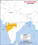
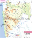
Located in the western part of India, Maharashtra is the third largest state in the country. The state covers an area of 307713 square Km. Maharashtra shares its borders with the states of Gujarat, Madhya Pradesh, Chhattisgarh, Telangana, Karnataka, Goa and the Union Territory of Dadra and Nagar Haveli. On the western side of the state lies the Arabian Sea.
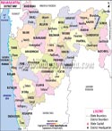
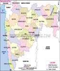
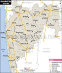
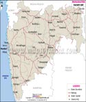
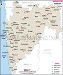
Divided into thirty six Districts, it has cities such as Mumbai, Pune, Aurangabad, Kolhapur, Solapur, Nagpur, Thane, Jalgaon and Amravati which have a distinct place on the map of the world. All the districts of Maharashtra are grouped into six divisions: Aurangabad Division, Amravati Division, Konkan Division, Nagpur Division, Nashik Division and Pune Division
The state which is home to one of the largest film industries of the world i.e. Bollywood, also boasts of being the largest contributor to India's National Industrial Output.
Maharashtra has a rich history which dates back to many centuries. During the 3rd and 4th century BC, the region was under the rule of the Mauryas. Other dynasties that ruled the region from time to time include the Satavahana dynasty (first century B.C.), Rashtrakuta dynasty (8th to the 10th century), Western Chalukyas (10th and 12th century). The Yadava dynasty (12th to 14th century) was defeated by the Delhi Sultanate. The decline of the Delhi Sultanate in 1347, led to the rise of the Bahamani Sultanate which ruled the state till 1518 when it split in five different kingdoms. The region was also under the rule of the Mughals. The 16th century saw the rise of the Marathas with Shivaji establishing a Maratha Empire. By the 18th century, the Maratha Empire had considerably expanded under the Peshwas and came to control large parts of India. Though the Marathas suffered a setback during the Third Battle of Panipat in 1761; they quickly recovered. Their power was finally crushed during the Third Anglo-Maratha War fought during 1817-1818. Thereafter, the region passed into the hands of the British who governed the western part of the state as Bombay Presidency (1843 to 1936) which included Karachi and parts of northern Deccan apart from many princely states in Western India. Following independence, the Bombay State was created adding some small princely states in Deccan and Kolhapur to the erstwhile Bombay Presidency. The Deccan States and Kolhapur were also included in the new state. In 1960, the Bombay State was divided into Maharashtra and Gujarat.
There are numerous places to visit in this state. Some of them include Lonavala, Khandala, Matheran, Panchgani, Mahabaleshwar and UNESCO World Heritage Sites of Ajanta and Ellora, Elephanta Caves and Chhatrapati Shivaji Terminus.
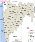
A number of national and state highways pass through this state . A few of them are NH -3, 4B, 4C, 6, 44, 8, 65, 13, 63, 26B, and many more.
To visit the hills in this state, including Lonavala, Mahabaleshwar, Chikhaldar and Toranmal, the best time is during the Monsoons. However, if you want to avoid rains, you can visit the state between October and March.
By Air: There are two airports in Mumbai itself. The city has one of the major airports of India, Chhatrapati International Airport which connects the country to Sharjah, New York, Singapore, Hong Kong, Mauritius, Dubai, Kuala Lumpur, Munich, Frankfurt, Muscat, Ahmedabad, Delhi, Jaipur, and many others. The other is the domestic airport, Santa Cruz Domestic Airport. Apart from these, there are airports in other cities of the state, which include Pune, Nagpur, Aurangabad and Kolhapur.
By Rail: The headquarters of the Central Railways, Chhatrapati Shivaji Terminus is located in Mumbai. All the cities of Maharashtra are well connected by Rail, Pune, Nashik, Nagpur, Kolhapur, Aurangabad and Amravati, also have their own railway stations.
By Road: All major cities are easily accessible by road. Regular interstate and intrastate bus services are available to reach other cities of the country.
Maharashtra State Information |
|
|---|---|
| Capital | Mumbai |
| Date of formation | 1. May. 1960 |
| Governor | Bhagat Singh Koshyari |
| Chief Minister | Uddhav Thackeray |
| Tourist attractions | Gateway of India, Murud-Janjira Fort, Elephanta Island, Aurangabad Caves |
| Festivals | Makar Sankranti, Ganesh Chaturthi |
| Major dance and music forms | Vasudev Dance, Lavni Dance, Dhangari Gaja, Tamasha |
| Arts and crafts | People of the Warli tribe create ritualistic paintings on cow dung-plastered walls; Paithani saris; Mashru and Himroo fabrics |
| Languages | Marathi, English, Hindi |
| Area | 307,713 km2 |
| Population (Census 2011) | 112372972 |
| Rivers | Godavari, Penganga, Bhima, Varna, Parvara, Mula |
| Forests and wildlife sanctuaries | Pench NP, Tadoba NP, Nagzira National Park, Nawegoan NP, Devlagaon NP, Gugamal NP. |
| State animal | Giant squirrel |
| State bird | Yellow-footed green pigeon |
| State flower | Jarul |
| State tree | Mango |
| Major crops | Paddy, wheat, sugarcane, oranges |
| Factoids | Gharapuri, just outside Mumbai, has seven beautiful rock-cut caves carved between the 6th and 7th centuries AD. |
| Kolis were among the first residents of the archipelago or arc of seven islands that later became Mumbai. | |
| No. of Districts | 36 |
| Location Map | Outline Map | Physical Map |
| Elevation Map | Lat Long Map | District Map |
| Rail Map | Road Map | Tehsil Map |
| River Map |
| Forest Map | Wildlife Sanctuaries Map | Sex Ratio Map |
| Handicrafts Map | Industrial Map | Agriculture Map |
| Mineral Map |
| History | Geography | Weather |
| Topography | Festivals | Facts |
| Rivers and Lakes | Soil and vegetation | District Fact Sheet |