| Disclaimer: All efforts have been made to make this image accurate. However Mapping Digiworld Pvt Ltd and its directors do not own any responsibility for the correctness or authenticity of the same. |
In terms of area, Karnataka is the eighth biggest state in India. The capital of Karnataka is Bengaluru or Bangalore which is dubbed as the information technology capital of India.
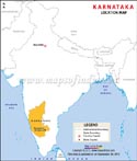
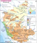
The state forms a part of the Deccan Plateau. It shares its borders with the Arabian Sea in the west, Maharashtra in the north, Kerala in the southwest, Goa in the northwest, Tamil Nadu to the southeast and Andhra Pradesh to the east. The economy of the state is dependent on manganese, gold, coffee, oilseed, sandalwood and silk manufacturing.
More than 90% of the gold produced in India is produced in the southern part of Karnataka. Hospet and Bellary are the two districts in the state where manganese ore are predominantly excavated.
Karnataka holds the top rank in producing raw silk, coffee, and sandalwood oriented goods. The service sector of the state comprises Consultancies, Real Estate, Academic Institutions, Travel and Tourism, Insurance and Hotel Industry.
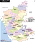
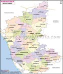
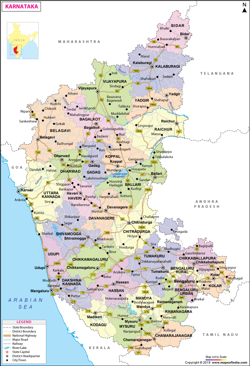
A map of Karnataka shows that there are 30 districts in the state and they are as follows:
Bangalore Rural, Bagalkote, Belgaum, Bangalore Urban, Bidar, Bellary, Chamarajanagar, Bijapur, Chikkamagaluru, Chikkaballapur, Dakshina Kannada, Chitradurga, Dharwad, Davanagere, Gulbarga, Gadag, Haveri, Hassan, Kolar, Kodagu, Mandya, Koppal, Raichur, Mysore, Shimoga, Ramanagara, Udupi, Tumkur, Yadgir, and Uttara Kannada. All these districts come under four divisions and they are as follows:
Belgaum Division, Bangalore Division, Mysore Division, and Gulbarga Division.
Bangalore Rural, Bangalore Urban, Chitradurga, Chikkaballapur, Kolar, Davanagere, Shimoga, Ramanagara, and Tumkur districts.
Belgaum division
Belgaum, Bagalkot, Dharwad, Bijapur, Haveri, Gadag, and Uttara Kannada districts.
Gulbarga Division
Bidar, Bellary, Koppal, Gulbarga, Yadgir, and Raichur districts.
Mysore Division
Chikamagalur, Chamarajanagar, Hassan, Dakshina Kannada, Mandya, Kodagu, Udupi, and Mysore districts.
Given below are the 30 districts of Karnataka and their major details:
| District | District Code | Created | Headquarters | Subdivisions | Area | Population (As of 2011) |
|---|---|---|---|---|---|---|
| Bagalkot | BK | 08/15/97 | Bagalkot | Badami, Bagalkot, Hungund, Bilgi, Mudhol, Jamkhandi, | 6,575 km2 (2,539 square mile) | 1890826 |
| Bangalore Urban | BN | 11/01/56 | Bengaluru | Anekal, Bangalore East, Bangalore North, Bangalore South | 2,208 km2 (853 square mile) | 9588910 |
| Bangalore Rural | BR | 08/15/86 | Bengaluru | Doddaballapura Devanahalli Nelamangala Hoskote | 2,259 km2 (872 square mile) | 987257 |
| Belgaum | BG | 11/01/56 | Belagavi | Bailahongal Athni Chikodi Belgaum Hukkeri Gokak Raybag Khanapur Saundatti Ramdurg | 13,415 km2 (5,180 square mile) | 4778439 |
| Bellary | BL | 11/01/56 | Ballari | Hospet Bellary Hoovina Kampli Kudligi Hadagalli Siruguppa Sanduru | 8,450 km2 (3,260 square mile) | 2532383 |
| Bidar | BD | 11/01/56 | Bidar | Bidar Bhalki Basavakalyan Aurad Homnabad | 5,448 km2 (2,103 square mile) | 1700018 |
| Bijapur | BJ | 11/01/56 | Vijapura or Vijayapura | Indi Bijapur Sindgi Muddebihal Bagevadi Basavana | 10,494 km2 (4,052 square mile) | 2175102 |
| Chamarajanagar | CJ | 08/15/97 | Chamarajanagar | Gundlupet Chamrajnagar Yelandur Kollegal | 5,101 km2 (1,970 square mile) | 1020962 |
| Chikballapur | 09/10/07 | Chikballapur | Chikballapur Bagepalli Gauribidanur Chintamani Sidlaghatta Gudibanda | 4,524 km2 (1,747 square mile) | 1254377 | |
| Chikmagalur | CK | 11/01/56 | Chikkamagaluru | Kadur Chikmagalur Mudigere Koppa Sringeri Narasimharajapura Tarikere | 7,201 km2 (2,780 square mile) | 1137753 |
| Chitradurga | CT | 11/01/56 | Chitradurga | Chitradurga Challakere Holalkere Hiriyur Molakalmuru Hosadurga | 8,440 km2 (3,260 square mile) | 1660378 |
| Dakshina Kannada | DK | 11/01/56 | Mangaluru | Beltangadi Bantwal Puttur Mangalore Sulya | 4,560 km2 (1,760 square mile) | 2083625 |
| Davanagere | DA | 08/15/97 | Davanagere | Davanagere Channagiri Harpanahalli Harihar Jagalur Honnali | 5,924 km2 (2,287 square mile) | 1946905 |
| Dharwad | DH | 11/01/56 | Dharwad | Hubli Dharwad Kundgol Kalghatgi Navalgund | 4,260 km2 (1,640 square mile) | 1846993 |
| Gadag | GA | 08/24/97 | Gadag | Mundargi Gadag-Betigeri Nargund Shirhatti Ron | 4,656 km2 (1,798 square mile) | 1065235 |
| Gulbarga | GU | 11/01/56 | Kalaburagi | Aland Afzalpur Chitapur Chincholi Jevargi Gulbarga Sedam | 10,951 km2 (4,228 square mile) | 2564892 |
| Hassan | HS | 11/01/56 | Hassan | Arkalgud Alur Belur Arsikere Hassan Channarayapattana Sakleshpur Holenarsipur | 6,814 km2 (2,631 square mile) | 1776221 |
| Haveri | HV | 08/24/97 | Haveri | Hangal Byadgi Hirekerur Haveri Savanur Ranibennur Shiggaon | 4,823 km2 (1,862 square mile) | 1598506 |
| Kodagu | KD | 11/01/56 | Madikeri | Somvarpet Madikeri Virajpet | 4,102 km2 (1,584 square mile) | 554762 |
| Kolar | KL | 11/01/56 | Kolar | Kolar Bangarapet Mulbagal Malur Srinivaspur | 3,969 km2 (1,532 square mile) | 1540231 |
| Koppal | KP | 08/24/97 | Koppal | Koppal Gangawati Yelbarga Kushtagi | 7,189 km2 (2,776 square mile) | 1391292 |
| Mandya | MA | 29 August 1939 (1 November 1956) | Mandya | Maddur Krishnarajpet Mandya Malavalli Pandavapura Nagamangala Shrirangapattana | 4,961 km2 (1,915 square mile) | 1808680 |
| Mysore | MY | 11/01/56 | Mysuru | Hunsur Heggadadevana kote Mysore Nanjangud Krishnarajanagara T.Narsipur Piriyapatna | 6,854 km2 (2,646 square mile) | 2994744 |
| Raichur | RA | 11/01/56 | Raichur | Lingsugur Devadurga Raichur Manvi Sindhnur | 6,827 km2 (2,636 square mile) | 1924773 |
| Ramanagara | 09/10/07 | Ramanagara | Kanakapura Channapatna Magadi Ramanagara | 3,556 km2 (1,373 square mile) | 1082739 | |
| Shimoga | SH | 11/01/56 | Shivamogga | Hosanagara Bhadravati Shikaripura Sagar Sorab Shimoga Thirthahalli | 8,477 km2 (3,273 square mile) | 1755512 |
| Tumkur | TU | 11/01/56 | Tumakuru | Gubbi Chiknayakanhalli Kunigal Koratagere Pavagada Madhugiri Sira Tumkur Tiptur Turuvekere | 10,597 km2 (4,092 square mile) | 2681449 |
| Udupi | UD | 08/25/97 | Udupi | Karkal Udupi Kundapura | 3,880 km2 (1,500 square mile) | 1177908 |
| Uttara Kannada | UK | 11/01/56 | Karwar | Bhatkal Ankola Honnavar Haliyal Karwar Joida Mundgod Kumta Sirsi Siddapur Yellapur | 10,291 km2 (3,973 square mile) | 1436847 |
| Yadgir | 12/30/09 | Yadgir | Shorapur Shahpur Yadgir | 5,273 km2 (2,036 square mile) | 1172985 |
Believing the data of 2011 census, the state had a literacy rate of 75.60%, in which 82.85% of males being literate and 68.13% are females. Some of the renowned educational institutions in Karnataka are:
| Karnataka State Information | |
|---|---|
| Capital | Bengaluru |
| Date of formation | 1. Nov. 1956 as Mysore, but was renamed Karnataka on 1.Nov.1973 |
| Governor | Vajubhai Rudabhai Vala |
| Chief Minister | Siddaramaiah |
| Tourist attractions | Mysore City Palace, Chamundi Hill, Stone Chariot in Hampi |
| Festivals | Kar Hunnive, Hampi Utsav |
| Major dance and music forms | Simha Nutrya, Yakshagana |
| Arts and crafts | Bidri; Chitragars' wood chiselling; specialised card game Ganjifa. |
| Languages | Kannada, Kodava, Tulu |
| Size | 191,791 sq. km |
| Population (Census 2011) | 61,130,704 |
| Rivers | Krishna, Tungabhadra, Cauvery, Kabini |
| Forests and wildlife sanctuaries | Bandipur WS, Nagarhole NP, Mudumalai NP |
| State animal | Asian elephant |
| State bird | Indian roller |
| State flower | Lotus |
| State tree | Sandalwood |
| Major crops | Rice, jowar, coffee |
| Factoids | Another name for Karnataka is Karunadu. |
| The central dome of Muhammad Adil Shah's tomb, the Gol Gumbaz of Bijapur, is the second largest in the world. | |
| No. of Districts | 30 |
| Travel to Bangalore | Travel to Belur | Travel to Coorg |
| Travel to Halebid | Travel to Hampi | Travel to Mangalore |
| Travel to Mysore |
| Bangalore To Coimbatore | Bangalore To Mangalore | Bangalore To Puttaparti |
| Bangalore To Hyderabad | Bangalore To Ooty | Bangalore To Shirdi |
| Bangalore To Madurai | Bangalore To Panaji | Bangalore To Thrissur |