| Disclaimer: All efforts have been made to make this image accurate. However Mapping Digiworld Pvt Ltd and its directors do not own any responsibility for the correctness or authenticity of the same. |
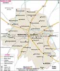
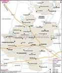
Bellary District in east Karnataka owes its nomenclature to Durugamma, established goddess of the state. Shrouded in antiquarian history the Bellary finds mention in the epic Ramayana and the chronicles of the legendary Satavahana dynasty.
The district occupying an area of 8,447 sq. km encompasses the latitudinal parallels ranging from 14°30' to 15°50' north and to the longitudinal meridians of 75°40' to 77°11' east. Raichur district on the north by Dharwad district on the west, Chitradurga and Davangere districts on the south and Anantapur, Kurnool districts of Andhra Pradesh on east form Bellary's geographic borders.
As per the 1991 Census the population of Bellary stands at 16.53 lakhs. The people mainly follow agricultural practices cultivating Cotton, Jowar, Groundnut, Paddy, Sunflower and Cereals which some work in the naturally endowed metallic and non-metallic mine fields.
Bellary has a well-developed tourism sector, which draws tourists to its: