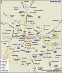
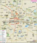
| *Mangaluru (Mangalore) City Map showing Major roads, Education Institutes, Hotels, Hospitals and other places of interest. |
| Disclaimer: All efforts have been made to make this image accurate. However Mapping Digiworld Pvt Ltd and its directors do not own any responsibility for the correctness or authenticity of the same. |
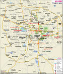
Mangalore, an important educational and industrial port city of Karnataka is situated on the west coast, at the confluence of Nethravathi and Gurupura rivers. The city is located at 12° 52 ' N latitude and 74 ° 49' E longitude, bounded in the east by the Western Ghats and bounded in the west by the Arabian sea. Mangalore is in the Dakshin Kannada district of Karnataka, about 326 kilometers from Bengaluru, the capital of the state.
Mangalore city is spread out over an area of 132.45 square kilometers. The two rivers -Nethravathi and Gurupura encircle the city. Nethravathi flows in the south of the city and Gurupura flows in the north of the city. The rivers form an estuary in the south west of the city before flowing into the Arabian Sea. The new Mangalore sea port, India's ninth largest sea port is located north of the city.
The total length of the roads network in the city is 888.9 kilometers. Three national highways pass through the city. NH 17 links Mangalore to Panvel ( in Maharashtra ), Udipi and Kannyikumari (in Kerala). N 48 links Mangalore with Bengaluru. NH 13 links Mangalore with Karkal , passes through Andhra Pradesh and ends at Solapur in Maharashtra.
The main roads in Mangalore are the K S Rao Road which runs through the center of the city, and the Falnir Road, which runs in the south of the city. There are many hotels in the city located around the K S Rao Road. Fahrir Road has many company offices around it.
The city has a domestic airport at Bajpe about 15 kilometers north from the city center. The Bejai Kavoor Road leads to the airport. The Karnataka State Road Transport Corporation (KSRTC) bus stand is in the north of the city in Bejai. There is another bus stand near the Town Hall, which is an important landmark of the city
The city has a broad gauge railway track and a meter gauge track running in the east. Two railway stations cater to the city. The first one is Mangalore Central located at Hampankatta in the center of the city and the second is Mangalore Junction located at Kankanady. Mangalore is connected to Tamil Nadu (Chennai ) through the Southern railway line and to Maharashtra through the Konkan railway line.
The city has a number of developed parks such as the Kadri Park in the eastern part of the city and Kings Park in the north. The district's sole cricket stadium the Mangala Stadium is in Mangalore.
In the city the important landmarks and tourist interest spots are
Some of the educational institutions in the city are