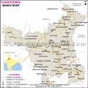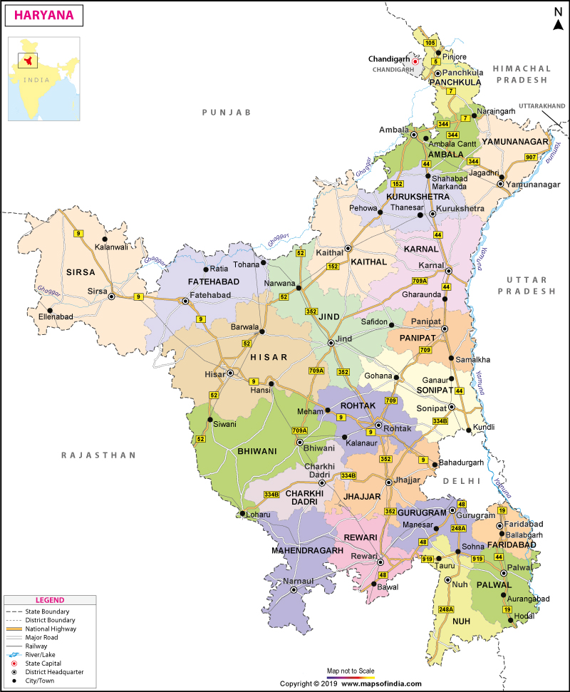
| *Map showing major roads, railways, rivers, national highways, etc. |
| Disclaimer: All efforts have been made to make this image accurate. However Mapping Digiworld Pvt Ltd and its directors do not own any responsibility for the correctness or authenticity of the same. |
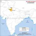
Haryana is a state in Northern India. The state shares its boundaries with Rajasthan in the south and west, Himachal Pradesh and Punjab in the north, and the territory of Delhi in the east. The capital of Haryana is Chandigarh and it is also the capital of the neighboring state of Punjab. However, the biggest city of the state is Faridabad. The state was formed on 1 November, 1966.
The total area of the state is 17,070 sq miles or 44,212 km2 which makes it the 20th biggest state in India by area. As laid down by the census performed in 2011, the population of the state is 27,761,063, making it the 16th most populated state in India. The density of population in Haryana is 1,485.212/sq miles or 573.443/km2.
Haryana is a non-coastal, interior state. It is located at an altitude of 200 meters to 1200 meters or 700-3600 feet over sea surface. Geographically, the state can be divided into the following regions:
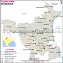
The major rivers of the state are as follows:
Yamuna, Sarasvati, Ghaggar, Markanda, and the Tangri river.
Woodlands cover a total area of 1,553 km2 of the state. The variety of flora in the state includes eucalyptus, mulberry, kikar, pine, babul and shisham. A wide variety of fauna is seen in Haryana comprising nilgai, blackbuck, fox, panther, jackal, mongoose, and wild dog. Over 300 varieties of birds are seen in the state.
The literacy rate of the state is 76.4% and the state occupies the 17th position in India in terms of literacy. About 90% of the population of the state are Hindus, 6.2% are Sikhs, 0.10% Christians, and 4.05% are Muslims. In addition, there are a small number of Jains living in the state. The official language of the state is Hindi. Other languages spoken in the state include Haryanvi, Sanskrit, English, Punjabi and Ahirwati.
Industries like business process outsourcing (BPO), manufacturing, retail and agriculture are the backbone of the state's economy. Service industries also make a significant contribution to the economic development of the state.
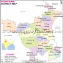
Districts in Haryana
There are 22 districts that make up the state of Haryana and they are as follows:
Gurgaon Division
Palwal District, Faridabad District, Mahendragarh District, Gurgaon District, Mewat District, and Rewari District
Ambala Division
Kaithal District, Ambala District, Panchkula District, Kurukshetra District, and Yamuna Nagar District
Rohtak Division
Karnal District, Jhajjar District, Rohtak District, Panipat District, and Sonipat District
Hisar Division
Fatehabad District, Bhiwani District, Jind District, Charkhi Dadri District, Hisar District, and Sirsa District.
Given below are the names of the well-known educational institutes in the state:
Haryana Agricultural University, Hissar, YMCA University of Science and Technology, NIT Kurukshetra, University Institute of Engineering and Technology, Kurukshetra University, Deenbandhu Chhotu Ram University of Science and Technology, Manav Rachna College of Engineering, The Technological Institute of Textile & Sciences, Bhiwani, Maharishi Dayanand University at Rohtak University Institute of Engineering & Technology, University Campus (UIET, Rohtak), ITM University at Gurgaon, Manav Rachna International University at Faridabad, Kurukshetra University at Kurukshetra, Chaudhary Devi Lal University at Sirsa, Guru Jambheshwar University of Science & Technology at Hisar, Chaudhary Charan Singh Haryana Agricultural University, Maharishi Markandeshwar University, Mullana, National Dairy Research Institute, Pandit Bhagwat Dayal Sharma PGIMS (Post Graduate Institute of Medical Sciences) Rohtak, and Management Development Institute (MDI) in Gurgaon.
The state of Haryana is famous for housing the following tourist attractions:
Kurukshetra, Chandigarh, Sultanpur National Park, Panchkula, Dumdama Lake, Taliyar, Surajkund and Morni Hills.
Some of the Major Towns in Haryana
Haryana State Information |
|
|---|---|
| Capital | Chandigarh |
| Date of formation | 01/11/66 |
| Governor | Kaptan Singh Solanki |
| Chief Minister | Manohar Lal Khattar |
| Tourist attractions | Sultanpur NP, Rock Gardens, Dumdama Lake |
| Festivals | Gugga Naumi, Lohri Basant Panchmi |
| Major dance and music forms | Sarangi/Ras Leela, Phag Dance |
| Arts and crafts | Shoes called tilla or kasuri juttis are made from buffalo and goat hide; panja dhurries |
| Languages | Hindi, Haryanvi, Punjabi, Sanskrit, Ahirwati, English |
| Size | 44,212 sq. km |
| Population (Census 2011) | 25351462 |
| Rivers | Yamuna, Sarasvati, Ghaggar, Markanda, and the Tangri |
| Forests and wildlife sanctuaries | Sultanpur NP, Kalesar NP, Simbalawara WS |
| State animal | Blackbuck |
| State bird | Black francolin |
| State flower | Lotus |
| State tree | Peepal |
| Major crops | Sugarcane, groundnut, paddy, maize |
| Factoids | Many invaders like the Huns and Alexander's army swept through Haryana. |
| Gugga Naumi is a festival that is observed by both Hindus and Muslims. It honours Gugga Pit who could cure snake bites. | |
| No. of District | 22 |