
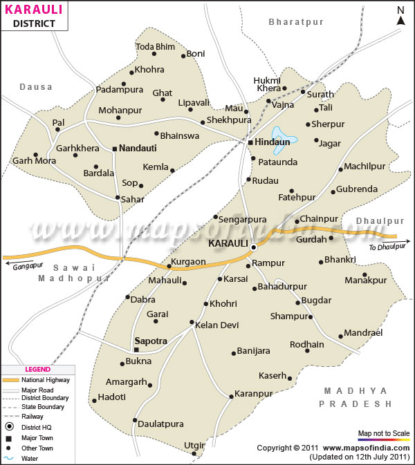
| *The Map showing National Highway, Major Roads, District Head Quarter etc in the district of Karauli, Rajasthan. |
| Disclaimer: All efforts have been made to make this image accurate. However Mapping Digiworld Pvt Ltd and its directors do not own any responsibility for the correctness or authenticity of the same. |
Karauli is a well-known district in the state of Rajasthan. The headquarters of the district is located in the town of Karauli. Karauli is a poular commercial hub and is home to plenty of industries.
Karauli district in Rajasthan is spread over an area of 5530 sq km. The district is surrounded by the districts of Dholpur, Bharatpur, Dausa and Sawai Madhopur. The Chambal River flows through the district. The rugged landscape of Karauli makes it an ideal place for traveling.
The climate of Karauli district is mainly dry due to its closeness to the desert. The summer months are hot while the winter months are cool. The ideal time for Karauli travel is between the months of November and February. The weather during this part of the year is fine.
Being a popular tourist destination, there are a number of tourist attractions in Karauli district. The region is known for its scenic beauty and idyllic charm. The rich heritage is also an added advantage. Travelers can opt for plenty of sightseeing trips to these tourist attractions. Some popular places worth a visit in the district are:
Mandrayal Fort
Chambal River
Madan mohanji
Kailadevi
Mehndi
Travelers can conveniently come to Karauli. The nearest airport is located in the capital city of Jaipur. There are various transport options available for coming to Karauli. Train services link the district with places like Delhi, Mumbai and other significant cities of the country. Buses ply between Karauli and Udaipur, Agra, Jaisalmer and other places in Haryana and Punjab.| Facts of Karauli District | |
|---|---|
| State | Rajasthan |
| District | Karauli |
| District HQ | Karauli |
| Population (2011) | 1,458,248 |
| Growth | 20.55% |
| Sex Ratio | 861 |
| Literacy | 66.22 |
| Area (km2) | 5530 |
| Density (/km2) | 264 |
| Tehsils | Hindaun, Karauli, Mandrail, Nadoti, Sapotra, Todabhim |
| Lok Sabha Constituencies | Karauli-Dholpur |
| Assembly Constituencies | Hindaun, Karauli, Sapotra, Todabhim |
| Languages | Hindi, Rajasthani including Dhundhari |
| Rivers | Morel, Chambal, Gambhir |
| Lat-Long | 26.500073,77.10125 |
| Travel Destinations | Timangarh Fort, Mandrayal Fort, Untgiri/Devgiri Fort, Madan Mohan Ji Temple, Mahavir Ji Temple, Anjani Mata Temple, Balaji Temple, Kailadevi ji temple, Crocodile Santuary, Ateva Pond, Kailadevi Forest, Pachna Dam etc. |
| Government Colleges/Universities | Government College (Hindaun City), Government College (Karauli), Government College (Nadauti), Government College (Todabhim), Government Girls College (Karauli), Govt. College (Sapotra) etc. |