
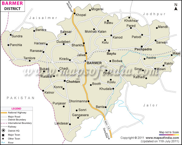
| *The Map showing National Highway, Major Roads, District Head Quarter etc in the district of Barmer, Rajasthan. |
| Disclaimer: All efforts have been made to make this image accurate. However Mapping Digiworld Pvt Ltd and its directors do not own any responsibility for the correctness or authenticity of the same. |
Located in the north western Indian state of Rajasthan , Barmer district is well-known for its hand block printing and carved wooden furniture.
The headquarters of the district is Barmer town. The major towns in the district are Chohatan, Baytu, Guda Malani, Jasol, Balotra and Siwana.
The town of Barmer is 224 kilometers from Jodhpur via Balotra and 198 kilometers via Panchpadra. The city of Jaisalmer is 157 kilometers from here while Jaipur is 588 kilometers away. The city of Ahmedabad is 485 kilometers from Barmer.
Barmer district is situated in the Thar Desert or the Great Indian Desert. The district is well-known for its dance and folk music. One can find the Bhopas or priest singers here. They are known for their music composition honoring war heroes and the deities of the region. Another type of folk musicians, the Muslim Dholis or drummers are also famous here.
The population of the district is around 1963758, according to 2001 census. Males constitute 10, 35,813 of the population while females comprise 9, 27,945 residents. The district is divided into 8 tehsils, 4 blocks and 1999 villages.
There are a number of attractions in Barmer district like Asotra, Batada Kua, Brahma Temple, Jain Temple, Jogmaya Temple, Mahabar Dunes, Surya Mandir Temple, Kher Temple, Viratra Mata Mandir, Kiradu, Nakora, Nimbari, Garib, Pipa Mandir and Bhimgoda.
One can see mud huts with beautiful folk motif decorations. The people wear colorful costumes and there are a number of shops selling traditional handicrafts. Barmer festival is held every year in the month of March which is a major tourist attraction of the district.| Facts of Barmer District | |
|---|---|
| State | Rajasthan |
| District | Barmer |
| District HQ | Barmer |
| Population (2011) | 2,603,751 |
| Growth | 32.52% |
| Sex Ratio | 902 |
| Literacy | 56.53 |
| Area (km2) | 28387 |
| Density (/km2) | 92 |
| Tehsils | Barmer, Baytoo, Chohtan, Gudha Malani, Pachpadra, Ramsar, Sheo, Siwana |
| Lok Sabha Constituencies | Barmer |
| Assembly Constituencies | Barmer, Baytoo, Chohtan, Gudamalani, Pachpadra, Sheo, Siwana |
| Languages | Rajasthani including Marwari, Hindi, English |
| Rivers | Luni |
| Lat-Long | 25.76032,71.429901 |
| Travel Destinations | Siwana fort, Asotra Temple, Kiradu Temple, Nakoda Temple, Viratra mata Temple, Mahabar Sand Dune etc. |
| Government Colleges/Universities | D.R.J. Government Girls College, Government College, Govt. College, M.B.C. Government Girls College, M.B.R. Government College etc. |