
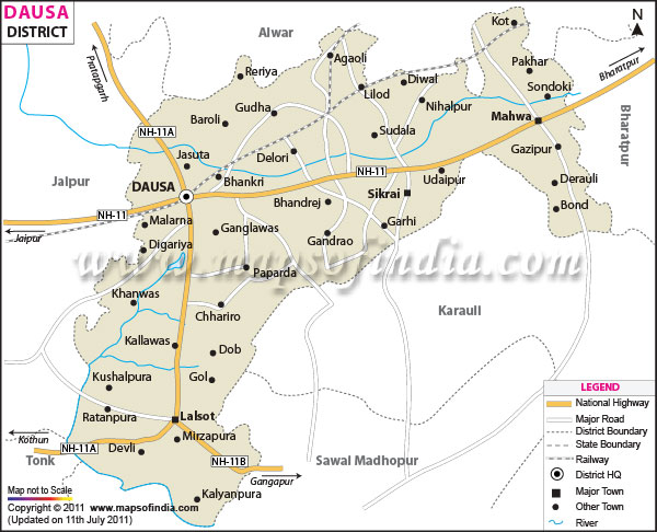
| *The Map showing National Highway, Major Roads, District Head Quarter etc in the district of Dausa Rajasthan. |
| Disclaimer: All efforts have been made to make this image accurate. However Mapping Digiworld Pvt Ltd and its directors do not own any responsibility for the correctness or authenticity of the same. |
Dausa district is located in the eastern part of the state of Rajasthan . The district of Dausa is surrounded by Alwar district in the north, Sawai Madhopur district in the south, Bharatpur district in the northeast, Karauli district in the southwest and Jaipur district in the west.
Dausa District Map gives detailed information about the district such as major road networks, places of interest, boundary of the district and other geographical features.
Population
According to the report of 2001 India census, Dausa district has a population of around 13,17,063.
Climate
The climate of Dausa is generally dry.
Getting to
Transportation in Dausa is well-developed. The nearest airport to Dausa is Sanganer Airport at Jaipur. The district is well-connected by an extensive rail network. The nearest railway station is Bandikui Junction.
Apart from rail access, the district is also connected with all the major towns and cities by road. NH-11 passes through Dausa and it connects Bikaner to the district of Agra.
Tourist Attractions
Some of the popular places of interests in Dausa are Mehandipur Balaji temple, Mataji Ka Mandir, Nilkanth Mahadev Temple and the Temples dedicated to Lord Shiva.
Festivals
Apart from sightseeing, the travelers can also enjoy the local festivals of Dausa. Some of them are Basant Mela, Dolchi Holi and Shekh Jamal's Urs.
Folk Music
The folk art of Hela-Khayal is a unique feature of the culture of the region.
| Facts of Dausa District | |
|---|---|
| State | Rajasthan |
| District | Dausa |
| District HQ | Dausa |
| Population (2011) | 1,634,409 |
| Growth | 24.09% |
| Sex Ratio | 905 |
| Literacy | 68.16 |
| Area (km2) | 3429 |
| Density (/km2) | 476 |
| Tehsils | Baswa, Dausa, Lalsot, Mahwa, Sikrai |
| Lok Sabha Constituencies | Dausa |
| Assembly Constituencies | Bandikui, Dausa, Lalsot, Mahwa, Sikrai |
| Languages | Hindi, Rajasthani including Dhundhari |
| Rivers | Banganga |
| Lat-Long | 26.804461,76.376152 |
| Travel Destinations | Bhandarej, Abhaneri, Jhajhirampura, Khawaraoji, Temple of Mehndipur Balaji, Neelkanth Temple, Gatolav, Chruch for Protestant Christians etc. |
| Government Colleges/Universities | Government Girls College, Government P.G College, Govt. College, Govt. Girls College, R.P. Government P.G. College, S.R.P. Government College etc. |