The state of Kerala has been divided into 14 districts for the sake of effective administration. Each district is governed by a District Collector which is appointed by the Kerala Government. These districts can be grouped into three parts on the basis of history, culture and geographical similarities.
Malabar, North Kerala - Districts of Kannur, Kasaragod, Kozhikode, Malappuram and Wayanad
Kochi region, Central Kerala - Districts of Eranakulam, Palakkad and Thrissur
Travancore, South Kerala - Districts of Alappuzha, Idukki, Kollam, Kottayam, Pathanamthitta and Thiruvananthapuram
The state of Kerala has been divided into 14 districts for the sake of effective administration. These are as follows:
Alappuzha District Map Ernakulam District Map Idukki District Map Kannur District Map
Alappuzha District Map Ernakulam District Map Idukki District Map Kannur District Map
Kasargod District Map Kollam District Map Kottayam District Map Kozhikode District Map
Kasargod District Map Kollam District Map Kottayam District Map Kozhikode District Map
Malappuram District Map Palakkad District Map Pathanamthitta District Map Thiruvananthapuram District Map
Malappuram District Map Palakkad District Map Pathanamthitta District Map Thiruvananthapuram District Map
Thrissur District Map Wayanad District Map
Thrissur District Map Wayanad District Map
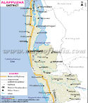
Alappuzha (Est. - 7 Aug 1957)
Alappuzha was known as Alleppey to the British. It is a low lying district of Kerala and the smallest in terms of area. It has the town of Alappuzha as its headquarters and is famed for its beautiful and calm backwaters. It has an excellent network of canals crisscrossing the region. Bound on the East by Pathanamthitta and South by Kollam, the district has the Arabian Sea on the remaining sides
Eranakulam (Est. - 1 Apr 1958)
With Thrissur to the North and the Arabian Ocean to the West; Idukki to the East and Alappuzha and Kottayam to the South; the district of Eranakulam has the port of Eranakulam as its district headquarters. This district boasts of a number of islands. Kochi a magnificent natural harbor stands on one such island.
Idukki (Est. - 26 Jan 1972)
The district headquarters of Idukki district lies in the town of Painavu. Idukki is a central district of Kerala. It shares boundaries with Tamil Nadu in the East, Thrissur in the North, Eranakulam and Kottayam in the West and Pathanamthitta in the South. It is a very beautiful region and its main attractions are the wildlife sanctuaries and hill stations.
Kannur (Est. - 1 Jan 1957)
Kannur, formerly Cannanore, is a northern district of Kerala. It shares its boundaries with the Kasaragod District of Kerala on the North and the Kozhikode District of Kerala in The South. To the east is the State of Karnataka and to the West is the Arabian Sea. The district derives its name from the city of Kannur, which is its headquarters. Kannur is famous for its extraordinary natural beauty, its dainty beaches, ancient temples and the associated festival rituals like the Theyyam. The major industries, besides tourism, are the handloom and choir work industries.
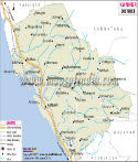
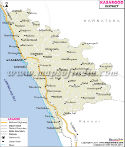
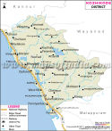
Kasaragod (Est. - 24 May 1984)
Kasaragod is the north most district of Kerala. It is bound in the north and east by the state of Karnataka, in the West by the Arabian Sea and in the South by the Kannur District of Kerala. Its headquarters is the port town of Kasaragod. The district of Kasaragod is of extreme historic importance and boasts of historical architectures which are its tourist attractions. The beautiful beaches and picturesque landscape of the district are breathtaking.
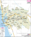
Kollam (Est. - 1 Nov 1956)
The Kollam town (erstwhile Quilon) is the headquarters of the Kollam district. It is an old sea port and the district's highlight is its commercial trade with China and other countries since historical times. The district is bound by Alappuzha and Pathanamthitta on the North and Thiruvananthapuram on the South.
Kottayam (Est. - 1 Nov 1956)
Kottayam is a district bound by Eranakulam, Idukki, Pathanamthitta and Alappuzha. The district headquarters are at Kottayam town. It is the first district in India to achieve 100% literacy. Kottayam is a historic region and its tourist attractions include the many lakes and forts.
Kozhikode (Est. - 1 Jan 1957)
Bound by Kannur, Wayanad and Malappuram in the North, East and West respectively, Kozhikode or former Calicut has been the seat of dramatic history, political conspiracy and flourishing trade. The headquarters of the district is the town of Kozhikode which is a major tourist attraction and an active port. He highlight of this district is its wildlife and lush vegetation.
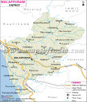
Malappuram (Est. - 16 Jun 1969)
Malappuram is the Southernmost of the northern districts of Kerala. It shares boundaries with Kozhikode and Wayanad in the north and Tamil Nadu in the East. Palakkad forms most of its East and South boundary while the district also shares a short boundary with Thrissur. Lush green forests, the dreamy Nilgiris, a scenic landscape and fertile riverbeds are part of the attraction of this quaint region. This district is noted for its eminent literary and political figures. The land has given birth to many seers. Malappuram town is its headquarters.
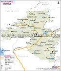
Palakkad (Est. - 1 Jan 1957)
The Palakkad district with its headquarters at Palakkad town is the seat of cultural growth and activities in Kerala. Bound by Tamil Nadu, Malappuram and Thrissur, the district is very influenced by the Tamil language and culture. The district is rich in Carnatic music exponents and conducts various cultural exchanges with the rest of the country.
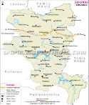
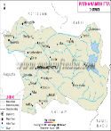
Pathanamthitta (Est. - 1 Nov 1982)
In 1982 the district of Pathanamthitta was formed and the town of Pathanamthitta was named its headquarters. It is surrounded by the districts of Kottayam, Idukki, Kollam and Alappuzha on all directions. It is an inland district. It is predominantly an agricultural district growing rubber and tea the most. The shrine at Sabarimala is a star attraction and about 10 million pilgrims visit it every year.
Thiruvananthapuram (Est. - 1 Nov 1956)
Thiruvananthapuram city, the headquarters of the Thiruvananthapuram district is also the state capital. It is the southern-most district of Kerala and the seat of administration, tourism and trade. Its many beaches, historic monuments and temples are the major tourist attractions. The district is also a great center for commercial trade.
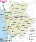
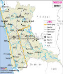
Thrissur (Est. - 1 Jul 1949)
Eranakulam and Idukki to the South, Palakkad to its East and Malappuram to its North, the district of Thrissur has Thrissur city as its headquarters. To the West is the Arabian Ocean and the district is known for its rich culture and traditions. The famous Pooram festival is celebrated in this city.
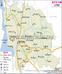
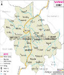
Wayanad (Est. - 1 Nov 1980)
The district headquarters of Wayanad are at Kalpetta. The district is known as Green Paradise due to the presence of dense forests and foliage. The district has a rich harvest of condiments and spices. Pepper, cardamom, coffee and tea are the major crops of this land. Kannur, Karnataka and Malappuram are its neighbors in the North, East and South. To the West is the district of Kozhikode.
| Sr. No. | District | District HQ | Population (2011) | Growth | Sex Ratio | Literacy | Area (km2) | Density (/km2) |
|---|---|---|---|---|---|---|---|---|
| 1 | Alappuzha | Alappuzha | 2127789 | 0.88% | 1100 | 95.72 | 1414 | 1501 |
| 2 | Ernakulam | Kakkanad | 3282388 | 5.69% | 1027 | 95.89 | 2951 | 1069 |
| 3 | Idukki | Painavu | 1108974 | -1.79% | 1006 | 91.99 | 4479 | 254 |
| 4 | Kannur | Kannur | 2523003 | 4.73% | 1136 | 95.1 | 2966 | 852 |
| 5 | Kasaragod | Kasaragod | 1307375 | 8.58% | 1080 | 90.09 | 1992 | 654 |
| 6 | Kollam | Kollam | 2635375 | 1.94% | 1113 | 94.09 | 2498 | 1056 |
| 7 | Kottayam | Kottayam | 1974551 | 1.07% | 1039 | 97.21 | 2203 | 896 |
| 8 | Kozhikode | Kozhikode | 3086293 | 7.20% | 1098 | 95.08 | 2345 | 1318 |
| 9 | Malappuram | Malappuram | 4112920 | 13.45% | 1098 | 93.57 | 3550 | 1058 |
| 10 | Palakkad | Palakkad | 2809934 | 7.35% | 1067 | 89.31 | 4480 | 627 |
| 11 | Pathanamthitta | Pathanamthitta | 1197412 | -2.97% | 1132 | 96.55 | 2462 | 453 |
| 12 | Thiruvananthapuram | Thiruvananthapuram | 3301427 | 2.07% | 1087 | 93.02 | 2192 | 1509 |
| 13 | Thrissur | Thrissur | 3121200 | 4.94% | 1108 | 95.08 | 3032 | 1026 |
| 1 | Wayanad | Kalpetta | 817420 | 4.71% | 1035 | 89.03 | 2131 | 383 |