| Disclaimer: All efforts have been made to make this image accurate. However Mapping Digiworld Pvt Ltd and its directors do not own any responsibility for the correctness or authenticity of the same. |
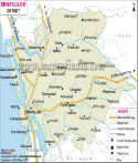
The potential of the district of Kannur as a tourist spot is very high compared to the other districts of Kerala.
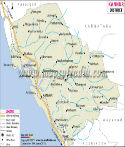
Kannur lies within 11° 40' and 12° 48' North latitudes and 74° 52' and 76° 07' East longitudes with a total area of 2,966 square kilometers. The total population of this district is 22,51,727 of which the number of males are 10,98,838 and number of females are 11,52,889.
The economy of Kannur is dependent on agricultural products. Coffee, rubber and tea form the primary plantations. Timber is also abundant in this district.
Some of the important tourist sites are-
Places in Kannur
Pulingome, Kozhichal, Cherupuzha, Peringom, Karthikapuram, Kokkanisseri, Payyannur, Ellmtara, Talipparamba, Payangadi, Srikandapuram, Vayathu, Kannapuram, Mattol, Cherukunnu, Pappinisseri, Valapattanam, Azhikkod, Chirakkal, Kannur, Muzhapilangadu, Edakkad, Dharmadam, Thalassery, Moderi, Kottayam, Kalavallur, Kottayam, Kattuparamba, Kannavam, Peravur, Muzhakunnu, Mattanur, Chavasseri, Iritti, Aralam, Kappad