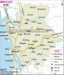
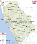
| *Map showing national highways, major roads, district headquarter, etc in Kollam District of Kerala. |
| Disclaimer: All efforts have been made to make this image accurate. However Mapping Digiworld Pvt Ltd and its directors do not own any responsibility for the correctness or authenticity of the same. |
Kollam is located in the the South west coast of Kerala. It is an old sea port of the Arabian sea coast. Kollam occupies an area of 2,491 sq. km. According to the census of 2001, the total population of the district is 25,84,118 with the population density of 1037 people per square kilometer.
Agriculture is the primary source of income in Kollam other than various industries of the region. Paddy, coconut, tapioca, rubber, pepper, mango, banana and cashew are grown here.