
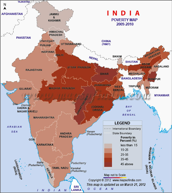
| *Map showing the highlights Indian states poverty percentage of 2009-10 as per census of India. |
| Disclaimer: All efforts have been made to make this image accurate. However Mapping Digiworld Pvt Ltd and its directors do not own any responsibility for the correctness or authenticity of the same. |
| 2009-2010 Poverty Percentage State Wise | |||
|---|---|---|---|
| States | Rural | Urban | Combined |
| Andaman & Nicobar | 0.4 | 0.3 | 0.4 |
| Andhra Pradesh | 22.8 | 17.7 | 21.1 |
| Arunachal Pradesh | 26.2 | 24.9 | 25.9 |
| Assam | 39.9 | 26.1 | 37.9 |
| Bihar | 55.3 | 39.4 | 53.5 |
| Chandigarh | 10.3 | 9.2 | 9.2 |
| Chhattisgarh | 56.1 | 23.8 | 48.7 |
| Dadra and Nagar | 55.9 | 17.7 | 39.1 |
| Daman and Diu | 34.2 | 33 | 33.3 |
| Delhi | 7.7 | 14.4 | 14.2 |
| Goa | 11.5 | 6.9 | 8.7 |
| Gujarat | 26.7 | 17.9 | 23 |
| Haryana | 18.6 | 23 | 20.1 |
| Himachal Pradesh | 9.1 | 12.6 | 9.5 |
| Jammu & Kashmir | 8.1 | 12.8 | 9.4 |
| Jharkhand | 41.6 | 31.1 | 39.1 |
| Karnataka | 26.1 | 19.6 | 23.6 |
| Kerala | 12 | 12.1 | 12 |
| Lakshwadeep | 22.2 | 1.7 | 6.8 |
| Madhya Pradesh | 42 | 22.9 | 36.7 |
| Maharashtra | 29.5 | 18.3 | 24.5 |
| Manipur | 47.4 | 46.4 | 47.1 |
| Meghalaya | 15.3 | 24.1 | 17.1 |
| Mizoram | 31.1 | 11.5 | 21.1 |
| Nagaland | 19.3 | 25 | 20.9 |
| Orissa | 39.2 | 25.9 | 37 |
| Puducherry | 0.2 | 1.6 | 1.2 |
| Punjab | 14.6 | 18.1 | 15.9 |
| Rajasthan | 26.4 | 19.9 | 24.8 |
| Sikkim | 15.5 | 5 | 13.1 |
| Tamil Nadu | 21.2 | 12.8 | 17.1 |
| Tripura | 19.8 | 10 | 17.4 |
| Uttar Pradesh | 39.4 | 31.7 | 37.7 |
| Uttarakhand | 14.9 | 25.2 | 18 |
| West Bengal | 28.8 | 22 | 26.7 |
| Total | 33.8 | 20.9 | 29.8 |