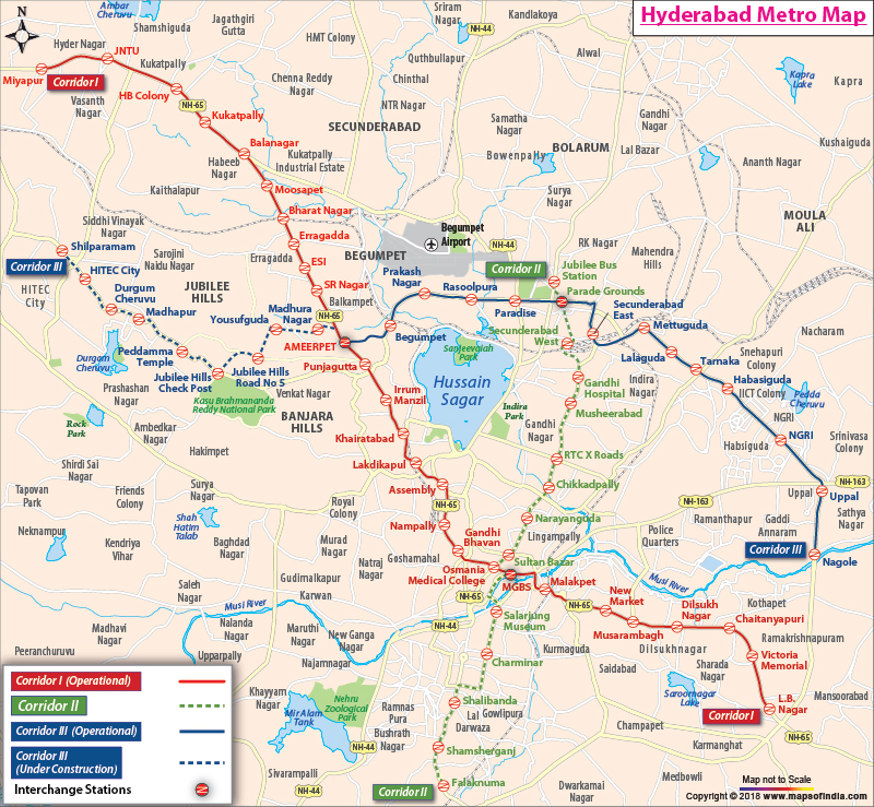
*Map showing all the Hyderabad Metro Routes and Corridors including Red, Green and Blue Corridors.
Disclaimer: All efforts have been made to make this image accurate. However Mapping Digiworld Pvt Ltd and its directors do not own any responsibility for the correctness or authenticity of the same.
The Hyderabad Metro Rail is a rapid transit system for the Hyderabad city of Telangana. It is developed as one of the world's largest transport system and is based upon the public-private partnership (PPP) model. The main driving force that led to the formation of this concept of metro project is the need for an eco-friendly and a fast transport system to fulfill the growing demands of Hyderabad.
Phases of Construction
The construction work for the metro will be carried out in two phases. The Phase I will be completed in six stages.
Phase I
Three lines are included in the Phase I and cover a distance of about 71 km. In the first stage, the metro routes between Nagole and Mettuguda and between Miyapur and S.R. Nagar will be made operational. The messages about the metros will flash in four different languages - English, Hindi, Telugu and Urdu in the display board in all the metro stations. In Phase I, following metro stretches will be functional:
Miyapur - L B Nagar - 29.87 km
Nagole - Shilparamam - 26.51 km
JBS - Falaknuma - 14.78 km
Phase II
The work for Phase II is expected to begin in 2015. It includes a stretch of about 80 km. The proposed routes included in Phase II are:
Miyapur - BHEL - Patanchervuu - 15 km
Faluknama - Shamshabad Airport - 12 km
LB Nagar - Vanasthalipuram - 4 km
ECIL - Tarnaka - 7 km
Nagole - LB Nagar - Faluknama - 15 km
JNTU - Shilparamam - Gacchibowli - 14 km
JBS - Alwal - 8 km
Gachibowli - ToliChowk - Lakdikapul - 17 km
Highlights of the Metro
Elevated world-class metro stations at a distance of approximately every kilometre.
It will connect major bus stations such as MGBS, Miyapur, Dilsukhnagar, Charminar Koti and Jubilee Bus Station.
Feeder bus services to metro stations from several areas are planned by GoT.
It connects all the major retail, offices and residential areas.
It is an eco-friendly mode of transport and reduces carbon, fuel emission.
It is connected to rail terminals at Nampally, Secunderabad and Begumpet.
Automatic ticket vending machine and fare collection system.
There are other facilities too like air conditioners, lifts, staircases, toilets, facilities for disabled, public address and information system and many more.
Awards
The Hyderabad metro project has already earned some awards even before its commencement.
"The Global Engineering Project of the Year Award" at Global Infrastructure Forum in New York on 28 February 2013.
"RoSPA (Royal Society for Prevention of Accidents) 'Gold' Award" for Construction Safety and Occupational Health for the year 2013 at Glasgow (UK) on 19 September 2013.
Some Interesting Facts about Hyderabad Metro
The proposed rail project covers a length of 72 km with metro stations at every kilometre.
The estimated cost of the project is Rs 14,132 crores.
The number of commuters in the year 2015 are expected at 14,76,000.
It is expected that the project will serve three "high density corridors" with a frequency of three to five minutes during the peak hours.
There are plans to collaborate with other public transport systems such as MMTS and RTC to integrate the metro rail with them.