
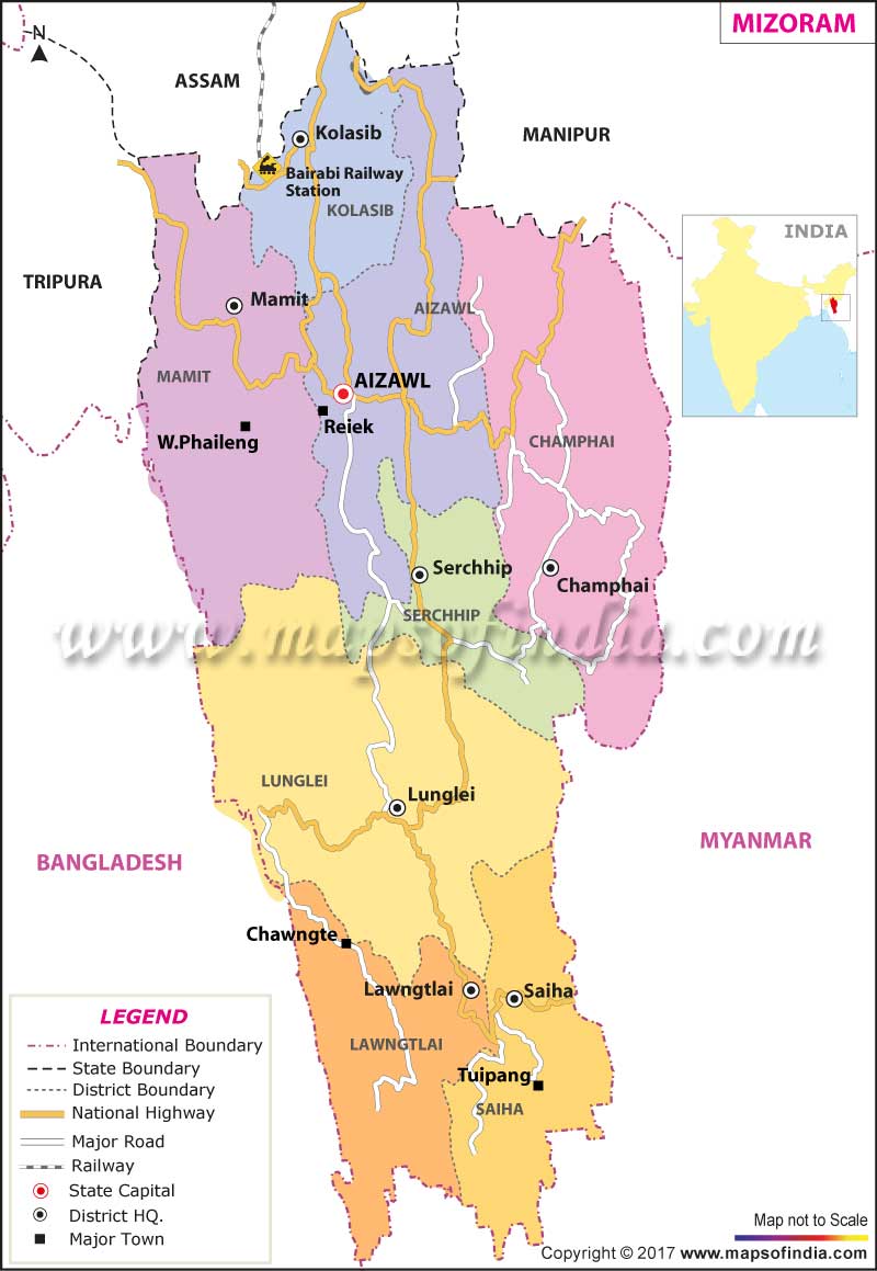
| *Map of Mizoram with major roads, railways, rivers, national highways, etc. |
| Disclaimer: All efforts have been made to make this image accurate. However Mapping Digiworld Pvt Ltd and its directors do not own any responsibility for the correctness or authenticity of the same. |
Mizoram is one of the seven sisters of Northeast India, bordered by Myanmar (formerly known as Burma) to its east and south, Bangladesh to its west, and the states of Manipur, Assam, and Tripura to its north.
Mizoram means 'Land of the Highlanders' and its local language is Mizo. The Mizo Hills, which dominate the state's topography, rise to more than 2000 m (6560 ft) near the Myanmar border. Aizawl, the state capital, is 1220 m (4000 ft) above sea level.
An amalgam of the former North and South Lushai Hill districts, Mizoram is a land of great natural beauty, an endless variety of landscape with rich flora and fauna, clusters of whispering pines and quaint villages with houses on stilts.
The Tropic of Cancer runs through the heart of Mizoram, and hence, it has a pleasantly temperate climate throughout the year. A land of steep hills and deep gorges, Mizoram's highest peak 'The Blue Mountain' rises to a height of 2165 metres. Important rivers that flow through this hilly state are Tlawang, Sonai, Tuivawl, Kolodine and Kamaphuli.
Mizoram has a single-chamber Legislative Assembly of 40 seats. The state sends two members to the Indian Parliament: one to the Rajya Sabha (Upper House) and one to the Lok Sabha (Lower House). The state has eight districts.
| Facts on Mizoram | |
|---|---|
| Official Website | www.mizoram.gov.in |
| Date of Formation | Feb 20, 1987 |
| Area | 21,087 sq km |
| Density | 52/Km2 |
| Population (2011) | 1,091,014 |
| Males Population (2011) | 555339 |
| Females Population (2011) | 541867 |
| No. of District | 8 |
| Capital | Aizawl |
| Rivers | Chimtuipui River, Tlawng, Tutis, Tuirial |
| Forests & National Park | Phawngpui Blue Mountain NP, Murlen NP, Dampa Tiger Reserve, Tawi WS |
| Languages | Mizo, Hindi, English |
| Neighbours State | Tripura, Assam, Manipur |
| State Animal | Hillock Gibbon |
| State Bird | Mrs. Hume's Pheasant |
| State Tree | Iron Wood |
| State Flower | Thar Senhri |
| Net State Domestic Product (2011) | 48591 |
| Literacy Rate (2011) | 91.58% |
| Females per 1000 males | 975 |
| Assembly constituency | 40 |
| Parliamentary constituency | 1 |
The hilly city Aizawl, located nearly 4,000 feet above sea-level, is a religious and cultural centre of Mizoram where indigenous handicrafts are also available. You will find Champhai, a beautiful resort on the Myanmar border. Tamdil, a natural lake with virgin forest, is 60 km from Aizawl and 10 km from tourist resort of Saitual, Vantawng falls, five km from hill station. Vantawng is the highest and most beautiful waterfalls in Mizoram. The department of tourism has opened tourist lodge at Aizawl, Lunglei, Champhai and wayside restaurant at Thingdawl, Hnahthial, recreational centre at Beraw Tiang and Alpine picnic hut at District Park near Zobawk.
The history of Mizoram is little is known. Between 1750 and 1850 the Mizo (formerly called Lushai) tribes migrated from the nearby Chin Hills and subjugated the indigenous population; these similar tribes were assimilated into their own society. The Mizo developed an autocratic political system based on some 300 hereditary chieftainships. The tribes of Mizoram remained unaffected by foreign political influence until the British annexed Assam in 1826 under the Treaty of Yandabo. During the next decades, Mizo raids into British territory led to occasional punitive expeditions by the British. Although not formally annexed until the early 1890s, the region had come under British control two decades earlier.
The Mizos are divided into several tribes - the Lushais, Pawis, Paithes, Raltes, Pang, Himars, Kukis etc. Society is based largely around tribal villages. The chief's house and the zawlbuk (community house for young, single men) are the focus of village life. The official languages of this state are Mizo and English. The literacy rate in Mizoram is about 92 percent, one of the highest in India. More than 80 percent of the population is Christians; the great majority is Protestants who were converted by missionaries during the 19th century. There are Muslim, Buddhist, and Hindu minorities. The nomadic Chakmas practice a combination of Hinduism, Buddhism, and animism (the worship of nature deities and other spirits
For the politically inclined people, a brief study on the government of Mizoram will be of much interest. Like every other Indian state, Mizoram government is also headed by the Chief Minister. He leads council of ministers who are responsible to an elected legislature. The Governor of Mizoram is the head of the state. The legislative assembly of Mizoram constitutes 40 members, who are elected by the people of the state in a duration of every five years. The High Court in Mizoram is situated at Guwahati. Aizawl, the capital of the state, has a bench of the Mizoram High Court.
About three-quarters of the population of Mizoram earn their living from agriculture. Both terraced cultivation and jhum (shifting) tillage (in which tracts are cleared by burning and sown with mixed crops) are practiced. The greater number of people in farming has reduced the traditional eight-year jhum cycle. Hence, there has been an accompanying decline in yields.
Mizoram is famous for the fibreless ginger. Paddy, maize, mustard, sugarcane, sesame and potatoes are the other prominent crops grown in this area. Small-scale irrigation projects are being developed to increase the crop yield.
The state does not have any other major industry. Small-scale industries include sericulture, handloom and handicrafts industries, sawmills and furniture workshops, oil refining, grain milling, and ginger processing.
The state has hotels of star and non star category catering to the needs of the tourists visiting Mizoram. Besides it has resorts, restaurants and cafes which cater to the needs of all segments of travellers.
CapitalThe capital Mizoram is Aizawl and it is also the biggest city of the state.
AreaThe state covers a total area of 8,139.4 sq miles or 21,087 sq. km.
PopulationAccording to the census performed in 2011, the population of the state is 1,091,014.
WeatherThe state of Mizoram features a pleasant weather. The temperatures are comfortable during the summer months and they range between 68°F and 84°F or 20°C and 29°C. In the winter months, the weather is not so cold and the temperatures range between 52°F and 70°F or 11°C to 21°C. The climate of the state is mostly controlled by torrential rains and the area experiences a large volume of precipitation during the months of May to September. During the winter months, there is insignificant amount of precipitation. The mean amount of precipitation in Mizoram is 100 inches or 254 cm every year. In the city of Aizawl, the volume of precipitation is approximately 82 inches or 208 cms. In Lunglei, another significant place in the state, the amount of precipitation is around 138 inches or 350 cms.
The name of the longest river in the state is Chhimtuipui and another name of this river is Kaladan. The source of this river is situated in the Chin state in Myanmar and the river flows across the Lawngtlai and Saiha districts in the southern end of the state. Subsequently, the stream reverts to the Rakhine province of Myanmar and ultimately pours into the Bay of Bengal close to Akyab, an important harbour in Sittwe, Myanmar. Despite the fact that various other torrents and rivers flow through the mountainous areas of the state, the most significant rivers in the state are as follows:
These rivers run across the northern parts of the state and ultimately meet the Barak River, which is an important river in the Cachar district. The Chhimtuipui River has its source in Myanmar and is a major stream in the southern part of the state. There are four branches in this river. The western section of the state is irrigated by the Khawthlang Tuipui River and its branches. Various major townships and communities such as Chittagong of Bangladesh are located at the opening of the stream. Prior to the achievement of freedom, other areas of India could only be reached via the river itineraries through Chittagong to the south and Cachar to the north. Later on, access was discontinued once there was division in the subcontinent and East Pakistan (present Bangladesh) was created.
The largest lake of the state is the Palak Lake and it is located in the Saiha district of the state. The Saiha district forms an important part of the state of Mizoram, India. The Palak Lake encompasses an area of approximately 74 acres or 30 hectares. Another popular lake in the state is the Tamdil Lake which is a natural lake. It lies at a distance of approximately 53 miles or 85 km from Aizawl.
Minerals found in the area include the following:
Petroleum and gas exploration operations are going on in the state relentlessly.
Most of the people of the state belong to various clans and communities that are ethnically or linguistically associated with each other. These clans and tribes are jointly named as Mizos where Mi stands for People and Zo stands for Hill. Other than Mizoram, these people inhabit places in Bangladesh, Myanmar, and other Northeastern states of India. The Mizo tribes comprise Lushei, Hmar, Lai, Paite, and Mara. The Hmar people are again subdivided into clans like Lungtau, Thiek, Khawbung, Darngawn, and Zote.
The popular cultural festivals in Mizoram are as follows:
Mim KutThe Mim Kut festival is normally observed in the months of August and September, following the cultivation of maize. People observe this festival by dancing, singing, drinking, and eating.
Pawl KutThe Pawl Kut festival refers to a straw harvesting festival since the word Pawl stands for straw. The festival is normally held in the month of December every year.
Chapchar KutThe Chapchar Kut is one more important festival which is observed in the month of March, following the conclusion of their most difficult job of Jhum maneuver, that is, forest-cleaning (removal of the leftovers of burning).
The popular dance forms in the state are Cheraw, Chheih Lam and Khuallam.
The official language of the state is Mizo. However, English, due to its significance in academics and government functions, is predominantly used. The Mizo language is blended with other languages such as the Lai, Mara, and Hmar.
Most of the people of the state belong to the Christian community. There are many churches in the state and some of the important churches are as follows:
Mizoram comprises of a formal system of education which ranges from elementary to university education, training to technical courses. By census 2011, the state has the third highest literacy rate in the country i.e 92%. There are about 3900 schools in the state which are either privately owned or are fully or partially managed by the government. The Ministry of Education looks after the colleges, universities and other educational institutions in the state. Mizoram University, which is the state University, has several departments and two professional institutions as well. Some of the reputed higher educational institutions in the state are ICFAI University, National Institute of Technology Mizoram, and Regional Institute of Paramedical and Nursing, Aizawl.
The state is not easily accessible due to inadequate transportation. As more than 90% of the area of the state is covered with narrow hills, construction of roads was a difficult and challenging task for the authorities. There is a road network of almost 8,500 kilometres in the state which is connected to national highways as well. National highways, state highways and district roads cover the majority of the area of the state. Near the state's capital Aizawl, there is Lengpui Airport which is linked to the Kolkata Airport. It is also linked to Silchar Airport of Assam which is about 200 kms away from Aizawl. Silchar in Assam is also the nearest railway station to the state which is at a distance of about 180 kms from the capital of the state. Helicopter service is there in the state and it connects the capital city to other cities of the states such as Lunglei, Serchhip, Kolasib, Hnahthial, Chawngte etc.