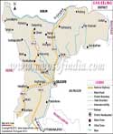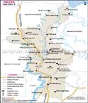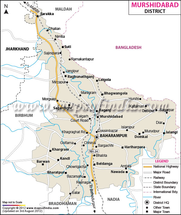
| *Murshidabad District Map highlights the National Highways, Major Roads, District Headquarter, etc. |
| Disclaimer: All efforts have been made to make this image accurate. However Mapping Digiworld Pvt Ltd and its directors do not own any responsibility for the correctness or authenticity of the same. |
Murshidabad district lies in the state of West Bengal, India and is the 18th district of the state. It is one of the important districts in the state as it has a rich historical as well as cultural background. It boost of serving as the last capital of the Bengal. It is also famous for the Battle of Plassey that took place between Nawab Siraj-Ud-Daula and Robert Clive of East India Company. The district is also popular for its special mango produce like the Shadulla, Ranipasand, Begum Pasand, Mulayamjam, Sharanga and Kohitur.
Murshidabad lies to the west of the state and is situated between latitudes 24 degrees 50 minutes north and 23 degrees 43 minutes north and longitudes 88 degrees and 46 minutes east and 87 degrees 49 minutes east. It covers a total of 5341 sq. kms. The state takes a shape of an isosceles triangle and the apex pointing to North-east side. River Padma flows through the eastern boundary of the state, which separates it from Malda district and Bangladesh. To the south is Nadia and Burdwan district. To the west lied Birbhum and Jharkhand state of India.
Murshidabad is well connected to other districts in the state and many other major cities in the country. National Highway No. 34 runs through the center of the district and is connected to other districts as well. A good railway network proves to be great transport means for the people of Murshidabad. It is well connected by road to the capital of state, Kolkata. Various major towns like Suti, Lalgola, Bhagwangola, Kargram, Bharatpur, Barwan, Nawada etc are well connected by major roads. The district head quarters lies in Baharampur.
The map of Murshidabad will provide great information regarding various important places and roads. The map can tell the exact location of the place you want to visit and also provide other information regarding tourism and monuments.
The district is divided by the river Bhagirathi into two equal parts. Both parts have different geographical features like the agriculture, geology, habitation and religion. The two areas are the Rarha area and the Bagri area.
According to 2011 report, Murshidabad has a population of 7,102,430 and the population density is 1,334 inhabitants per sq.kms. The literacy rate is 67.53 percent and has a sex ratio of 957 females per 1000 males. The language spoken here is Bengali and the religion here is predominantly Muslim.
| Facts of Murshidabad District | |
|---|---|
| State | West Bengal |
| District | Murshidabad |
| District HQ | Baharampur |
| Population (2011) | 7103807 |
| Growth | 21.09% |
| Sex Ratio | 958 |
| Literacy | 66.59 |
| Area (km2) | 5324 |
| Density (/km2) | 1334 |
| Tehsils | Beldanga I, Beldanga II, Berhampore, Bhagawangola I, Bhagawangola II, Bharatpur I, Bharatpur II, Burwan, Domkal, Farakka, Hariharpara, Jalangi, Kandi, Khargram, Lalgola, Murshidabad Jiaganj, Nabagram, Nawda, Raghunathganj I, Raghunathganj II, Raninagar I, Raninagar II, Sagardighi, Samserganj, Suti I, Suti II |
| Lok Sabha Constituencies | Jangipur, Barhampur, Murshidabad |
| Assembly Constituencies | Farakka, Samserganj, Suti, Jangipur, RaghunathGanj, Sagardighi, Lalgola, Bhagabangola, Raninagar, Murshidabad, Nabagram, Khargram, Burwan, Kandi, Bharatpur, Rejinagar, Beldanga, Baharampur, Hariharpara, Naoda, Domkal, Jalangi |
| Languages | Bengali, Hindi |
| Rivers | Bhagirathi, Jalangi, Hoongly |
| Lat-Long | 24.256981,88.240585 |
| Travel Destinations | The Hazarduari Palace, Hazarduari Museum, Madina, The Bachchawali Tope, Katra Mosque, Motijheel, Murshidabad District Museum etc. |
| Government Colleges/Universities | Berhampore College, Berhampore Girls' College, Dukhulal Nibaran Chandra College, Dumkal College, Hazi A.K. Khan College, Jangipur College, Jatindra Rajendra Mahavidyalaya, Kandi Raj College, Krishnath College, Lalgola College, Murshidabad Adarsha Mahavidyalaya, Muzaffar Ahmed Mahavidyalaya, Nabagram Amar Chand Kundu College, Nagar College, Nur Mohammad Smriti Mahavidyalaya, Panchthupi Haripada Gouribala College, Prof. Sayed Nurul Hasan College, Raja Birendra Chandra College, Rani Dhanya Kumari College, S.R. Fatepuria College, Sagardighi Mahavidyalaya, Sripat Singh College, Subhas Chandra Bose Centenary College etc. |