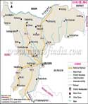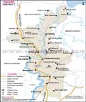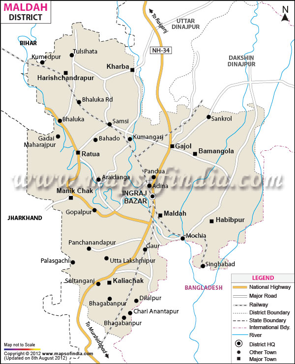
| *Malda District Map highlights the National Highways, Major Roads, District Headquarter, etc. |
| Disclaimer: All efforts have been made to make this image accurate. However Mapping Digiworld Pvt Ltd and its directors do not own any responsibility for the correctness or authenticity of the same. |
Malda has a rich colonial history and is well known for its natural beauty and the rivers. It has seen many great rulers in the past from the Buddhist, Hindus and the Muslim.
The district experienced extreme climate conditions and is found to be a very important district in West Bengal. During the British rule it was known as the English Bazaar.
Malda is situated on the confluence of the rivers Kalindi and Mahananda. It is located on latitude range is 24 degree 40 ' 20" N to 25 degree 32'08" N and longitude range is 87 degree 45' 50" E to 88 degree 28'10" E. The district occupies an area of 3,733.66 sq KM. the district is surround by Murshidabad district to the south, North Dinajpur to the north, and Bangladesh to the east. The west side shares its borders with Jharkhand and Bihar.
Malda district is well connected with roads and railway transport to different parts of the country. The railway station found here is named as Malda town. Most of the trains that are bound for North Bengal and North eastern states pass through Malda town station. The district also has National Highway 34 and the second National Highway No that passes through the district is NH-81. The head quarter is located at Ingraj Bazar. There are plenty of roads that connect to major towns like the Manik Chak, Maldah, Habibpur, Bamangola, Kahrab, Harishchadrapur, Samsi, Kaliachak and Bahgabanpur.
The Mahananda River divides Malda district into two regions. The Ganga River flows along the south western boundary. Some of the other rivers are the Tangoan, Kalindri, Bhagirathi, Punarbhaba and Pagla.
Malda had a population of 3,997,970 according to 2011 report and ranks 58th in India. The density of population per square kilometer is 1,071. The district recorded a sex ratio of 939 females per 1000 males. The literacy rate is 62.71 percent.
The district comprises of 59 percent of Muslim people, 40 percent Hindus and one percent of other religion. The language spoken here is Urdu, Bengali, Hindi and Maithili. There are also some regional languages as well.
Malda is a beautiful place and is rich in history. It boosts of various monuments, mosques, temples and various other buildings from the British and pre-British rule. The Jama Masjid, Nimsari tower, Raiganj bird sanctuary, museum, ruins of Gaur and Pandua etc are some of the interesting places to visit in Malda.
| Facts of Maldah District | |
|---|---|
| State | West Bengal |
| District | Maldah |
| District HQ | English Bazar |
| Population (2011) | 3988845 |
| Growth | 21.22% |
| Sex Ratio | 944 |
| Literacy | 61.73 |
| Area (km2) | 3733 |
| Density (/km2) | 1071 |
| Tehsils | Bamangola, Chanchal I, Chanchal II, English Bazar, Gazole, Habibpur, Harischandrapur I, Harischandrapur II, Kaliachak I, Kaliachak II, Kaliachak III, Maldah, Manikchak, Ratua I, Ratua II |
| Lok Sabha Constituencies | Maldaha-Uttar, Maldaha-Dakshin |
| Assembly Constituencies | Habibpur, Gazole, Chanchal, Harischandrapur, Malatipur, Ratua, Manikchak, Maldaha, Englishbazar, Mothabari, Sujapur, Baisnabnagar |
| Languages | Hindi, Bengali |
| Rivers | Ganges, Mahananda, Fulahar, Kalindri |
| Lat-Long | 25.175117,88.240585 |
| Travel Destinations | Baroduari / Boro Sona Mosque, Dakhil Darwaja, Firoz Minar, Chamkati Masjid, Chika Mosque, Luko Churi Gate, Kadam Rasul Mosque, Lattan Mosque, Kotwali Darwaja, Gumti Darwaza, Adina Dear Park, Pandab Dallan Minar, Atbart Dighi, Adina Mosque, Kutubshahi Masjid, Eklakhi Mausoleum etc. |
| Government Colleges/Universities | University of Gour Banga, Malda College, IMPS College of Engineering and Technology, Malda Polytechnic, Malda Medical College and Hospital, Malda Women's College, Gour Mahavidyalaya, Gazole Mahavidyalaya, Sultanganj College, Chanchal College, Harishchandrapur College, Samsi College, South Malda College, Pakuahat college etc. |