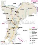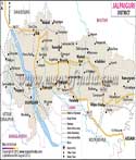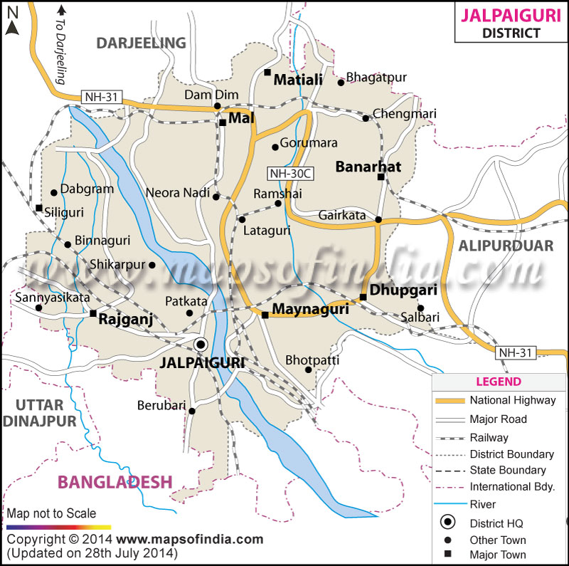
| *Jalpaiguri District Map highlights the National Highways, Major Roads, District Headquarter, etc. |
| Disclaimer: All efforts have been made to make this image accurate. However Mapping Digiworld Pvt Ltd and its directors do not own any responsibility for the correctness or authenticity of the same. |
Jalpaiguri is a district in West Bengal, India, which is known for its tea plantations and thick forests that boosts of wild life. Situated on the foothills of Himalayas,
the district has great potential for tourism, which means the district is full of rich flora and fauna and has beautiful natural beauty spread all across the district. It covers an area of 6, 245 sq kms.
Jalpaiguri is situtated between 26 degree 32'N and 88 degree 46'E. It is located in North of West Bengal and shares its borders with countries like Bangladesh and Bhutan, which lie to the south and north respectively. To the east are Assam and Darjeeling hills that expand further west and North West. The topography of the district comprises of hills, rivers and rivulets. The main rivers that you will find here are the Teesta River, Jaldhaka River, Torsa River, Neora, Dyna, etc.
Jalpaigur has a great network of roads and railways. There is a good scope for transport in the region. Jalpaigiri has National Highway No. 31 running from the district and National Highway No 30C as well. They connect well to the other parts of the state and country. The other major roads connect to towns like Alipur Duar, Kalchini, Madari Hat, BIrpara, Banarhat, Mainagur, Dhupgari, Rajganj, Matiali and Mal.
The major railway junction is new Jalpaiguri and is 40 KM from the town. Some of the other railway stations are the Jalpaiguri Road and Jalpaiguri that helps connect people with the rest of the country. Most of the North eastern trains pass through Jalpaiguri Road.
The population of Jalpaiguri was 3,403,204 in 2001 and has an average population density of 547 per Sq KM. There were around 1,753,278 males and 1,649,926 females in 2001. It is basically a rural district that has a large population residing in villages. Almost 1,839,036 people were literate in 2001.
Tea industry is the major industry here. However, the district is agriculture based and most of the population is engaged in agriculture. Timber is also famous in the district and has many timber industries that are flourishing.
Tourism is a fairly new industry, which has great potential at present and in the future as well. it comprises of diverse flora and fauna and can attract vast chunk of tourists from within the country and outside. Important attractions are the sanctuaries, National parks and the Tiger reserves. Visitors can get an opportunity to see Rhinoceros, Leopard, Gaur and elephant.
| Facts of Jalpaiguri District | |
|---|---|
| State | West Bengal |
| District | Jalpaiguri |
| District HQ | Jalpaiguri |
| Population (2011) | 3872846 |
| Growth | 13.87% |
| Sex Ratio | 953 |
| Literacy | 73.25 |
| Area (km2) | 6227 |
| Density (/km2) | 621 |
| Tehsils | Nagrakata, Dhupguri, Mekhliganj, Maynaguri, Mal, Dabgram-Phulbari, Jalpaiguri, Rajganj |
| Lok Sabha Constituencies | Jalpaiguri (Sc) |
| Assembly Constituencies | Dhupguri, Maynaguri, Jalpaiguri, Rajganj, Dabgram-Phulbari, Mal, Nagrakata |
| Languages | Bengali, Hindi, Nepali, Bijori- a Munda |
| Rivers | Teesta, Torsa, Jaldhaka, Raidak, Dyna, Neora, Sankosh |
| Lat-Long | 26.70636,89.015922 |
| Travel Destinations | Garumara National Park, Lataguri, Chapramari Wild Life Sanctuary, Chalsa, Jaldapara, Hollong, Madarihat, Buxa Tiger Reserve, Jatileshwar Temple, Vamori Devi Temple, Bhabani Pathak Temple, Devi Choudhurani Mandir, Jalpesh Temple |
| Government Colleges/Universities | Ananda Chandra College, Ananda Chandra college of Commerce, P.D.Women's College, A.C.Training, Alipurduar College, Vivekananda College, Sukanta Mahavidyalaya, Falakata College, Parimal Mitra Smiriti Mahavidyalaya, Jalpaiguri Law College, Birpara College, Shahid Kshudiram Mahavidyala, Nani Bhattacharjee Smarak Mahavidyalaya., Maynaguri College, North Bengal St. Xavier's College etc. |