About Uttarakhand
History and Geography
People and Culture
Government
Economy
Climate
Pincode
STD Code
Governors
Chief Minister
Districts of Uttarakhand
Nainital
Uttarkashi
Pithoragarh
Chamoli
Uttarakhand Map
Location Map
Physical Map
Mineral Map
Forest Map
Agricultural Map
Roads
Rivers
Tehsils
Railways
Cities in Uttarakhand
Dehradun
Haridwar
Nainital
Mussoorie
Almora
Travel to Uttarakhand
Places to Visit in Uttarakhand
Temple in Uttarakhand
Pilgrimages in Uttarakhand
Wildlife Sanctuaries
Jim Corbett National Park
Char Dham Yatra
Education
Engineering Colleges in Uttarakhand
Hotel Management Colleges in Uttarakhand
Medical Colleges in Uttarakhand
Maps
Political Map
Physical Map
Outline Map
Railway Map
Road Map
More...
States of India
Uttar Pradesh
Maharashtra
Rajasthan
Karnataka
Tamilnadu
More...
Cities of India
Delhi
Mumbai
Kolkata
Chennai
Bangalore
More...
India Travel
Hotels in India
Tourist Places in India
Hill Stations
Beaches in India
Religious Places in India
More...
Utilities
Pin Codes
STD Search
Railway Time Table
Flight Schedule
Distance Calculator
More...
Education
Exam Date Sheet
Election
Assembly Polls in India
Parliamentary Constituencies
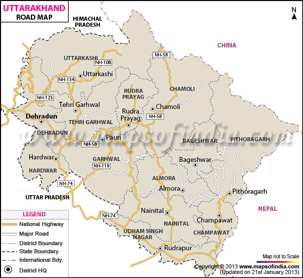
Uttarakhand Road Map
* Map showing entire road network of Uttarakhand.
Disclaimer:
All efforts have been made to make this image accurate. However Mapping Digiworld Pvt Ltd and its directors do not own any responsibility for the correctness or authenticity of the same.
Road Map of Uttarakhand
Almora Road Map
Bageshwar Road Map
Chamoli Road Map
Champawat Road Map
Dehradun Road Map
Haridwar Road Map
Nainital Road Map
Garhwal Road Map
Pithoragarh Road Map
Rudra prayag Road Map
Tehri Garhwal Road Map
Udham Singh Nagar Road Map
Uttarkashi Road Map
Last Updated on:
Mar 02, 2019