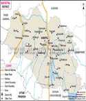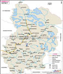
| *Map showing National Highway, Major Roads, District Headquarters, Major Towns, Rivers and etc in Nainital District. |
| Disclaimer: All efforts have been made to make this image accurate. However Mapping Digiworld Pvt Ltd and its directors do not own any responsibility for the correctness or authenticity of the same. |
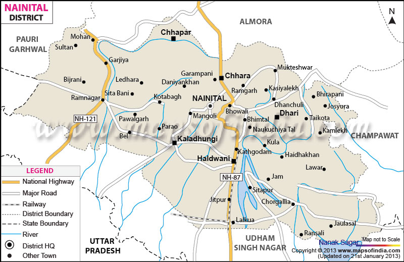
Nainital district of Uttarakhand has an area of 3422 square kilometers. The district is located between Longitude 80°14'E and 78°80' E and Latitude 29° 05' N and 29°05'N.
It is bounded by Almora district in the north and Udham Singh Nagar in the south. In the East, it is bounded by Champawat district and in the west by Pauri Garhwal district of Uttarakhand. The maximum temperature in the Nainital district is 40.2° C and the minimum is -5.4°C. .The average rainfall in the district is 1407mm.
Nainital district is located in the Kumaon area of Uttrakhand and is part of the Kumaon division of the state. The district is spread over hilly areas as well as the plains .The Himalayas lie to the north of the district, with the highest peak at Baudhanshtali (2623 meters) at Binayak. Forests of trees such oak, Chinar, Deodar, Sal and Pine cover the higher altitude in the hills making this district one of the greenest in the state.
The district has plain areas called the terai and bhabhar belt near the foothills of the mountains, towards the south, at the boundary with Udham Singh Nagar district. The River Kosi flows in the western part of the district. Many small rivulets such as Bhakra, Dabka, and Baur also flow in the district.
Nainital district is also called the Lake District of Uttarakhand due to the presence of many big and small lakes in the hills. Many towns are located near the lakes and some of them are major tourist spots in the state. Bhimtal, Sattal, Naukuchiyatal, Khurpatal, and Nainital are all lakes in the district.
For administration, the district is divided into 8 Tehsils and 8 development blocks. It has 1082 villages. The total population of the district is 762909, out of which rural population is 493859. There are four degree colleges and one Government University in the district, apart from many private and government schools.
The headquarters of the district is at Nainital. Nainital is also the divisional headquarter of the Kumaon Division of the state. The state high court is located at Nainital. The other important towns in the district are Haldwani, Kathgodam Bhimtal, Naukuchiyatal, Ramnagar, Mohan, Garjiya, Halrakhan, Bhowali, Bijrani,Ramgarh, and Mukhteshwar.
The district has a good network of roads connecting the hilly towns. National highway 87 starting from Uttar Pradesh border passes through Pantnagar and connects it to Nainital and Bhowali. It then goes on to the adjoining district of Almora and ends at Karna Prayag. This Highway is the most important connection for the upper regions of the state. Bhowali town is the road junction for Kumaon area and all the hill towns.
Haldwani is the third most populous town in the state and an important road and rail link. The town is close to Kathgodam. The railway station at Kathgodam is an important terminus for the entire state as it is on the broad gauge line of the North East railways connecting the district and the state with Delhi and other towns in the plains and also with Kolkata in West Bengal.