
| Disclaimer: All efforts have been made to make this image accurate. However Mapping Digiworld Pvt Ltd and its directors do not own any responsibility for the correctness or authenticity of the same. |
| Country | Capital |
|---|---|
| India | New Delhi |
List of States and Capitals of India |
||
|---|---|---|
| 1 | Andhra Pradesh | Amaravati |
| 2 | Arunachal Pradesh | Itanagar |
| 3 | Assam | Dispur |
| 4 | Bihar | Patna |
| 5 | Chhattisgarh | Naya Raipur |
| 6 | Goa | Panaji |
| 7 | Gujarat | Gandhinagar |
| 8 | Haryana | Chandigarh |
| 9 | Himachal Pradesh | Shimla |
| 10 | Jharkhand | Ranchi |
| 11 | Karnataka | Bengaluru (formerly Bangalore) |
| 12 | Kerala | Thiruvananthapuram |
| 13 | Madhya Pradesh | Bhopal |
| 14 | Maharashtra | Mumbai |
| 15 | Manipur | Imphal |
| 16 | Meghalaya | Shillong |
| 17 | Mizoram | Aizawl |
| 18 | Nagaland | Kohima |
| 19 | Odisha | Bhubaneswar |
| 20 | Punjab | Chandigarh |
| 21 | Rajasthan | Jaipur |
| 22 | Sikkim | Gangtok |
| 23 | Tamil Nadu | Chennai |
| 24 | Telangana | Hyderabad |
| 25 | Tripura | Agartala |
| 26 | Uttar Pradesh | Lucknow |
| 27 | Uttarakhand | Dehradun, Gairsain (Summer) |
| 28 | West Bengal | Kolkata |
Union Territories of India |
||
|---|---|---|
| 1 | Andaman and Nicobar Islands | Port Blair |
| 2 | Chandigarh | Chandigarh |
| 3 | Dadra and Nagar Haveli and Daman and Diu | Daman |
| 4 | Delhi | New Delhi |
| 5 | Lakshadweep | Kavaratti |
| 6 | Puducherry (Pondicherry) | Pondicherry |
| 7 | Jammu and Kashmir | Srinagar (Summer), Jammu (Winter) |
| 8 | Ladakh | Leh |
Governed by a parliamentary system, India is a federal constitutional republic and is the world's most populous democracy. There are 29 states and seven union territories in the country. Each state and union territory has an administrative, legislative and judicial capital.
An administrative capital is one where all the offices of the executive government are situated. A legislative capital is the one where the state assembly convenes. A judicial capital is the one where the territorial high courts are located.
All the states and two union territories, Puducherry and the National Capital Territory of Delhi, have an elected form of government and legislatures. They are headed by a Chief Minister, who is elected for a term of five years. Other union territories are directly ruled by the Central government. Under the States Reorganisation Act of 1956, the states were reorganised on the basis of language.
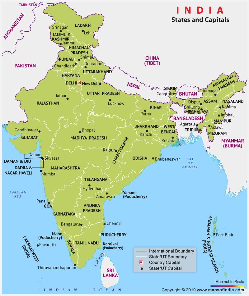
The map above shows locations of all the states and union territories along with their capitals. The names of the states are written in capital letters and the capitals are marked with a black dot. State and international boundaries are also marked in the map. The table below the map lists the capital of India and the capitals of the states and the union territories.