
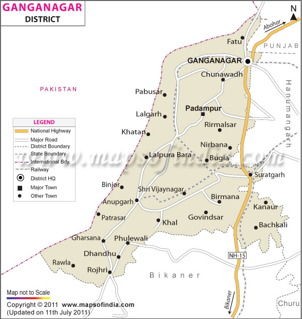
| *The Map showing National Highway, Major Roads, District Head Quarter etc in the district of Sri Ganganagar, Rajasthan. |
| Disclaimer: All efforts have been made to make this image accurate. However Mapping Digiworld Pvt Ltd and its directors do not own any responsibility for the correctness or authenticity of the same. |
Ganganagar is a district located in the Indian state of Rajasthan . The population of the district is 1788487 as per 2001 census. The town of Sri Sri Ganganagar is the administrative headquarters of the district.
Location of Sri Ganganagar District
The district is located in the northern most part of Rajasthan and occupies an area of approximately 7984 square kilometer. It is surrounded by the state of Haryana in the northeastern side, Bikaner in the south, Hanumangarh in the east and Pakistan in the northwest and west.
Divisions of Sri Ganganagar District
Sri Ganganagar District in India has 6 sub-divisions, 9 tehsils and 7 Panchayat Samitis. Approximately 2839 villages of the district are inhabited by human population. The district has 10 towns in total and as many as 320 Gram Panchayats.
History of Sri Ganganagar District
In ancient times Sri Ganganagar was a part of the Bikaner District, which was formed by Rao Bika in the year 1488. Thereafter, King Jaisingh started expanding the area of this district. During the 15th century a new Bikaner was formed. On 30th March, 1949 the district of Sri Ganganagar was created out of Bikaner District.
Economy of Sri Ganganagar District
Agriculture and animal husbandry are the main economic activities of the district. Oilseeds, sugarcane, cotton and food grains are the main crops that are cultivated over here. Besides these, there are a large number of small and large scale industries too.
Tourist Attractions in Sri Ganganagar District
Tourist attractions are abundant in Sri Ganganagar, thereby making the district a popular spot for excursions and tours. Some of the primary places of interest that are worth taking a look are:
A good network of roads and railways connects Sri Ganganagar District to the rest of India. The BRO or Border Roads Organization is responsible for the maintenance of the district roadways. There are trains from Kandla (Gujarat) as well from Pathankot (Punjab) to this place.
| Facts of Ganganagar District | |
|---|---|
| State | Rajasthan |
| District | Ganganagar |
| District HQ | Ganganagar |
| Population (2011) | 1,969,168 |
| Growth | 10.04% |
| Sex Ratio | 887 |
| Literacy | 69.64 |
| Area (km2) | 10990 |
| Density (/km2) | 179 |
| Tehsils | Sri Ganganagar, Sri Karanpur, Sadulshahar, Padampur, Raisinghnagar, Suratgarh, Anoopgarh, Shri Vijaynagar, Gharsana |
| Lok Sabha Constituencies | Ganganagar, Bikaner |
| Assembly Constituencies | Sri Ganganagar, Anupgarh, Karanpur, Raisinghnagar, Sadulshahar, Suratgarh |
| Languages | Hindi, Seraiki, Sindhi, Punjabi, English, Bagri |
| Rivers | ----- |
| Lat-Long | 29.391748,73.551865 |
| Travel Destinations | Gurudwara Buddha Johad, Baror, Dada Pamparam's Dera, Laila-Manjnu ki Mazar (tomb), Chanana-Dham, Anoopgarh Fort etc. |
| Government Colleges/Universities | C.B.R.G Government Girls P.G. College, D.B.R.A. Government College, Government College, Government Girls College, Government Law College etc. |