
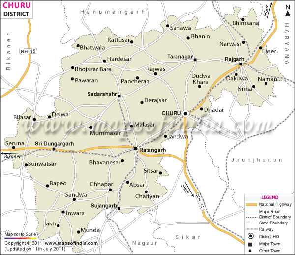
| *The Map showing National Highway, Major Roads, District Head Quarter etc in the district of Churu Rajasthan. |
| Disclaimer: All efforts have been made to make this image accurate. However Mapping Digiworld Pvt Ltd and its directors do not own any responsibility for the correctness or authenticity of the same. |
Churu District lies in the Indian state of Rajasthan . Churu is the administrative headquarters of Churu district. Haryana is in the east of Churu district and Bikanir district lies to its west.
The Churu District has 6 tehsils namely Churu, Taranagar, Ratangarh, Rajgarh, Sujangarh and Sardarshahar. The Churu District Map gives information about the district boundary, main roads, towns and national highway passing through the district.
History of Churu district:
Churu district was a part of the state of Bikaner till India gained Independence. It came to existence only in the year 1948. The major towns of the district are Sujangarh, Ratangarh, Rajgarh and Bidasar.
Tourist Places in Churu district:
Black Buck Sanctuary Tal Chhapar: Located in Churu district, the Talchhapar Sanctuary is known for its rare black-buck. Apart from the black-buck, some of the other wild animals spotted here are jungle cat, chinkara and varied species of migratory birds. This sanctuary is located at a distance of 85 kilometers from Churu.
Salasar Balaji : Balaji Temple is one the famous religious spots of the district. Two fairs are organized in this temple in the month of April. Salasar is located on National Highway No. 65 of Sujangarh in the district of Churu.
Kothari and Surana Haveli: Oswal Jain merchant families constructed these beautiful painted havelis. Malji's Haveli made by Malaji Kothari is the most popular haveli. Another famous haveli is the Surana Double Haveli. This haveli has about 111 windows and doors.
Some of the other places of interest are:
How to reach Churu district:
The Jaipur airport lies close to Churu district. Churu is connected with other cities like Jaipur, Delhi and Bikaner, by express trains. R.S.R.T.C runs regular buses to Churu district from various tourist destinations and nearby towns.
| Facts of Churu District | |
|---|---|
| State | Rajasthan |
| District | Churu |
| District HQ | Churu |
| Population (2011) | 2,039,547 |
| Growth | 6.01% |
| Sex Ratio | 940 |
| Literacy | 66.75 |
| Area (km2) | 16830 |
| Density (/km2) | 148 |
| Tehsils | Churu, Rajgarh, Ratangarh, Sardarshahar, Sujangarh, Taranagar |
| Lok Sabha Constituencies | Churu |
| Assembly Constituencies | Churu, Ratangarh, Sadulpur, Sardarsahar, Sujangarh, Taranagar |
| Languages | Hindi, Rajasthani including Shekhawati, Marwari |
| Rivers | ----- |
| Lat-Long | 28.323725,74.441757 |
| Travel Destinations | Salasar Dham Temple, Talchhapar Sanctuary, Kothari and Surana Haveli, Kanhaiya Lal Bagla Haveli, Sethani ka Johda, Chhatriyan, Gurudwara Sahib Sahwa, Venkteshwar Temple etc. |
| Government Colleges/Universities | G.H.S. Government P.G. College, Government College, Government Law College, Lohia Government College, M.J.D. Government College, S.B.D. Government PG College, S.K.D.L. Government Girls College etc. |