
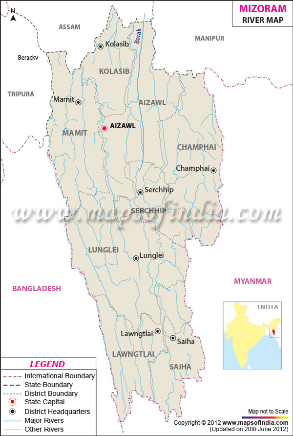
| *The Mizoram Rivers Network Map showing the River Flowing in and out of Mizoram. |
| Disclaimer: All efforts have been made to make this image accurate. However Mapping Digiworld Pvt Ltd and its directors do not own any responsibility for the correctness or authenticity of the same. |
Mizoram Rivers comprises a major division of the geography of Mizoram. It is assisted mainly by heavy rainfalls during monsoon seasons and intermittent rainfall during the year; nearly all of the Rivers in Mizoram are perpetual in nature.
The largest river in Mizoram is Chhimtuipui, (138.46 km in length). It originates in Myanmar Burma and passes through Lawngtlai and Saiha districts in the Southern Mizoram and lastly enters the Bay of Bengal at Myanmar. The river is in patches and has four tributaries. The western part of the river is drained by Khawthlangtuipui River (128 km in length) and its tributaries.
While many more rivers and streams flow through the hilly ranges of Mizoram, the most important and constructive rivers are the Tlawng (185.15 in length), Tuirial (11.53 in length) and Tuivawl (72.45 in length) which course through the northern territory and ultimately join the Barak River in Assam.
Rivers like Mat (90.16 in length), Tuichang (120.75 in length) and Tuipui (86.94 in length) fall in the southern part of Mizoram. The rivers of Mizoram are the chief source of water for the people of the state. The perpetual rivers of the state nourish the lush green vegetation of Mizoram.
Some of the other main rivers flowing through Mizoram are Tiak (159.39 km in length), Tuichawng (107.87 km in length), Teirei (70.84 km in length), Tuirini (59.57 km in length) and Serlui (56.33 km in length).