About Bihar
History and Geography
Information
Culture
Government
Economy of Bihar
Pincode
STD Code
Governors
Chief Minister
Districts of Bihar
Begusarai
Bhagalpur
Gaya
Gopalganj
Bihar Map
Location Map
Physical Map
Agricultural Map
Roads
Rivers
Tehsils
Railways
Cities in Bihar
Motihari
Chhapra
Patna
Bodhgaya
Travel to Bihar
Places to visit in Bihar
Hotels in Bihar
Education
Engineering Colleges in Bihar
Medical Colleges in Bihar
Universities in Bihar
Maps
Political Map
Physical Map
Outline Map
Railway Map
Road Map
More...
States of India
Uttar Pradesh
Maharashtra
Rajasthan
Karnataka
Tamilnadu
More...
Cities of India
Delhi
Mumbai
Kolkata
Chennai
Bangalore
More...
India Travel
Hotels in India
Tourist Places in India
Hill Stations
Beaches in India
Religious Places in India
More...
Utilities
Pin Codes
STD Search
Railway Time Table
Flight Schedule
Distance Calculator
More...
Education
Exam Date Sheet
Election
Assembly Polls in India
Parliamentary Constituencies
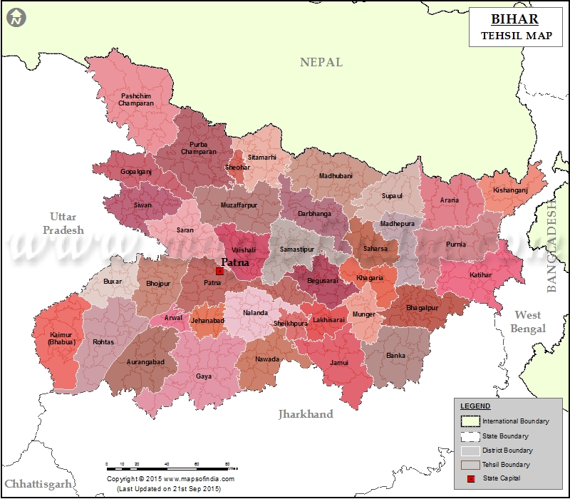
Bihar Tehsil Map
*Map highlights the district wise blocks in Bihar
Disclaimer:
All efforts have been made to make this image accurate. However Mapping Digiworld Pvt Ltd and its directors do not own any responsibility for the correctness or authenticity of the same.
Tehsil Map of Bihar
Araria Tehsil Map
Arwal Tehsil Map
Aurangabad Tehsil Map
Banka Tehsil Map
Begusarai Tehsil Map
Bhagalpur Tehsil Map
Bhojpur Tehsil Map
Buxar Tehsil Map
Darbhanga Tehsil Map
East Champaran Tehsil Map
Gaya Tehsil Map
Gopalganj Tehsil Map
Jamui Tehsil Map
Jehanabad Tehsil Map
Khagaria Tehsil Map
Kishanganj Tehsil Map
Kaimur Tehsil Map
Katihar Tehsil Map
Lakhisarai Tehsil Map
Madhubani Tehsil Map
Munger Tehsil Map
Madhepura Tehsil Map
Muzaffarpur Tehsil Map
Nalanda Tehsil Map
Nawada Tehsil Map
Patna Tehsil Map
Purnia Tehsil Map
Rohtas Tehsil Map
Saharsa Tehsil Map
Samastipur Tehsil Map
Sheohar Tehsil Map
Sheikhpura Tehsil Map
Saran Tehsil Map
Sitamarhi Tehsil Map
Supaul Tehsil Map
Siwan Tehsil Map
Vaishali Tehsil Map
West Champaran Tehsil Map
Last Updated on:
Feb 20, 2019