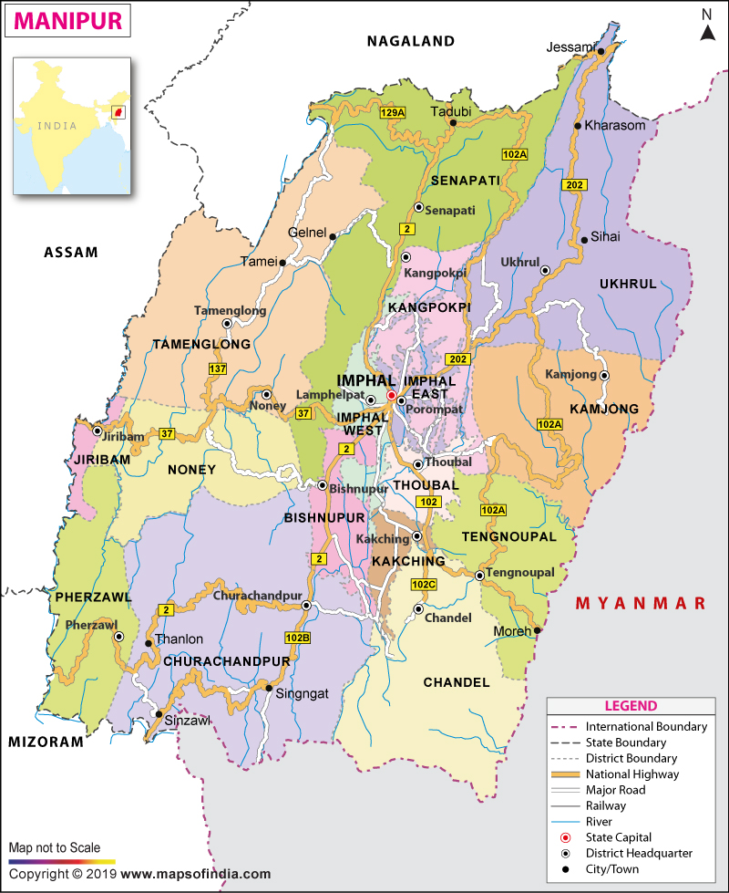
| *Map showing major roads, railways, rivers, national highways, etc. |
| Disclaimer: All efforts have been made to make this image accurate. However Mapping Digiworld Pvt Ltd and its directors do not own any responsibility for the correctness or authenticity of the same. |
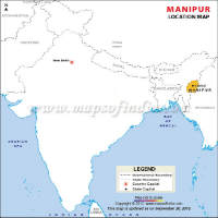
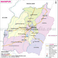
Manipur is situated in the Northeast region of India. Imphal is the capital of Manipur. The state comprises people of various cultures such as Kuki, Naga, Pangal and Mizo, who speak different languages. The total area covered by Manipur is 22,347 square kilometers. Manipur shares its borders with Nagaland, Mizoram, and Assam. The state shares its international borders with Myanmar.
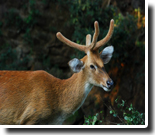
Manipur is paradise on earth. It literally means "The Jeweled Land". Manipur is richly endowed with natural beauty and splendour. It is home to Sangai, a rare species of deer and Siroy Lily, the only terrestrial lily grown on the hill tops of Siroi hill. St. Clair Grimwood described it as "A pretty place, more beautiful than many show places of the world." Late Pandit Jawaharlal Nehru paid a fitting tribute by describing it as "Jewel of India". Manipur is bounded by Nagaland to its north, Mizoram to its south, Upper Myanmar to its east and Cachar district of Assam to its west. Manipur comprises sixteen administrative districts.
| Facts on Manipur | |
|---|---|
| Official Website | www.manipur.gov.in |
| Date of Formation | Jan 21, 1972 |
| Area | 22,327 sq km |
| Density | 122/Km2 |
| Population (2011) | 2,966,889 |
| Urban Population in % (2011) | 32.45% |
| Males Population (2011) | 1,491,832 |
| Females Population (2011) | 1,475,057 |
| No. of District | 9 |
| Capital | Imphal |
| Rivers | Barak, Imphal and Iril |
| Forests & National Park | Keibul Lamjao NP, Shirui NP |
| Languages | Manipuri, Meitei |
| Neighbours State | Assam, Nagaland, Mizoram |
| State Animal | Sangai (Brow-antlered deer) |
| State Bird | Nongin |
| State Tree | Indian Mahogany |
| State Flower | Lilium mackliniae (Lily) |
| Net State Domestic Product (2011) | 29,684 |
| Literacy Rate (2011) | 75.48% |
| Females per 1000 males | 987 |
| Assembly constituency | 60 |
| Parliamentary constituency | 2 |
The history of Manipur is quite fascinating. In the year 1891, following the first Anglo-Manipuri war, the state was annexed by the British. There were many heroes who sacrificed their lives during the war. Yuvraj Tekendrajit and general Thangal were hanged after the British captured Imphal. It was after the independence of India in the year 1947 that a Manipur Constitution Act was established in order to ensure the prevalence of a democratic form of government. It was on 21 January 1972 that Manipur gained full statehood. Throughout the ages Manipur was known as Meiteileipak, Kangleipak and Meitrabak. Apart from these names, there were twenty other names by which the state was known.More Detail...
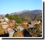
The state comprises a rich and diverse geography. The entire area covered by the state is 22,327 square kilometers. The state is situated in an oval-shaped valley, encompassing an area of approximately 700 square miles. A range of Blue Mountains surround the state and it is located at an elevation of 790 meters above sea level. The entire valley slope extends from the northern to the southern area. The northern cold winds are debarred from reaching the valley due to the presence of the mountain ranges. The four major basins that are situated in the state include Manipur River Basin, Barak River Basin, Yu River Basin and Lanye River Basin. There are as many as eight rivers in the Manipur river basin namely Manipur, Iril, Chakpi, Sekmai, Khuga, Thoubal, Nambul and Imphal.More Detail...
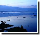
Manipur comprises immense natural beauty, majestic monuments, fabulous lakes and rivers, natural caves and many other attractions. Hence it has a strong and flourishing tourism industry. Imphal is the capital of Manipur and is home to prominent attractions such as Shree Govindajee Temple, Andro village, and the Manipur State Museum. The Loktak Lake is the largest freshwater lake in the entire northeast region. A popular tourist hotspot is the Keibul Lamjao National Park and home to many endangered species. You would also come across the floating islands of Shanghai and Shirui Lily at Ukhrul. Some other prominent destinations worth visiting are Shree Govindajee Temple, Lamka, NS Moreh. More Detail...
Imphal is the capital of Manipur and is a prominent tourist attraction. Over the years, modern Imphal has witnessed many changes and developments. The capital was split into East and West Imphal in 1997 and is known as West Imphal and East Imphal. The city is situated at 790 altitudes from the MS level. The climate is salubrious and experiences tropical monsoons every year. More Detail...
The state government is considered as the supreme governing authority of the Manipur state. The government body comprises legislative branch, governor and a judiciary. The President of India appoints the Governor of Manipur. The appointment process is made on the advice of the central government. Imphal, the capital of Manipur, houses the secretariat and Vidhan Sabha. A few of the major state level political parties in Manipur are the Federal Party of Manipur, Naga National Party, and Nikhil Manipuri Mahasabha among others. Apart from the aforementioned political parties, there are also the National People's Party (India) and Democratic Revolutionary People's Party. More Detail...
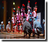
Manipuri society is characterised by its simplicity and egalitarian values. The people are warm and cooperative. Women enjoy high status in the society. Old people are given due respect and reverence. People here love games and sports and have given the world the game of Polo. Even though they are Hindu by religion, the Indian caste system is not the basis of social stratification. Instead, society is divided between the Meiteis, the Bamons (Brahmins of Indian origin), Pangans (Muslims, also of Indian origin) and lois (social outcasts, some of whom are descended from prisoners of war from Burma and India). Manipuris rarely intermarry, and even today, do not marry within the salai, as the original ten clans are known. Society is organised around neighborhoods, called leikais. All activities, from ear-piercing ceremonies, to festivals and cremations center around the leikai. The approval of the leikai is the highest the community-minded Manipuri can seek. More Detail...
The economy of Manipur is also on a constant rise. The positive role played by the government has indeed helped in boosting the economy of the state. There are as many as 7700 small-scale industries that are located in the state. A few of the small scale industries that have made a positive influence on the economy include handlooms, village industries, cottage industries and handicrafts. It is no hidden secret that the state government is playing a central role in boosting the overall economy of the state and strengthening the financial backbone. There are many small-scale companies manufacturing different items such as plastic, electronic goods and steel that has made a huge impact in strengthening the overall economy of the state. The establishment of a few cement industries have also played a major role in uplifting the economy of the state. In a bid to take the economy of the state to a greater level, the governmental bodies have decided to establish a number of training institutes so as to make the concerned people familiar with the latest technology that can benefit all industries. More Detail...
The present scenario in Manipur has witnessed a huge improvement. During the previous years, education in the state was primarily restricted among the elite sections of Manipuri society. A few of the possible reasons as to why education in the state took a backseat included communal clashes, economic blockades and a series of ongoing clashes that had a negative impact on the education system in Manipur over the past decade. The adoption of the new education system has indeed brought around a drastic change in the entire scenario of education. It is hard to deny the positive role of the educational institutions in bringing about a drastic increase in the number of students who have qualified with a higher percentage of the cut off marks. More Detail...
As per the data released by Census 2011, the total population of Manipur is 25,70,390. The rural population consists of 1,736,236, and the urban population is 8,34,154. According to Census 2011, population density is approximately 122; thus highlighting a total increase of 19 points as compared to the data released in the year 2001. Imphal West records the highest position and the density is approximately 856 per square kilometer. Thoubal occupies the second position as far as population density is concerned at approximately 708 Sq. Km. Tamenglong records the minimum population and the value ranged within 25 per single sq km and 32 per single sq km during the year 2011. Inhabitants of Manipur can be divided into as many as three ethnic communities namely, Meiteis, individuals inhabiting the valley and major tribes residing in the hills. It is possible to subdivide tribes living in the hills into two further ethno-denominations recognised as Kuki-Chins and Nagas. Language One of the other languages people speak in Manipur is Bishnupriya Manipuri. Bishnupriya Manipuri is spoken by as many as 4,50,000 people all over the world. A few of the places where people speak the same language are Myanmar, Bangladesh, Meghalaya, Tripura, Assam and Arunachal Pradesh. Manipur Media The media of Manipur is playing an important role in projecting the sentiments of the people and their opinions and views. The tabloid and the electronic media have flourished well. There are a number of local newspapers in the state and a single Imphal based television media called the ISTV. Televisions and satellite connectivity are available in almost each household. There is a great demand for cable network and the government has done well to distribute the satellite connections. However, the insurgent group, Revolutionary People's Front, has prohibited some of the channels like MTV, FTV and Channel V from being aired in the state. Hindi movies are also prohibited from being aired in the Imphal Valley.More Detail...
There are many places of interest in Manipur. Blessed with natural scenic beauty, it attracts several tourists who are enthralled and enchanted by the captivating sight of the place. A trip to this north eastern state enlightens the visitors with the varied topography and the colourful festivals of the state. The crystal clear water of the enchanting lake of Loktak, the sprawling green fields, picturesque landscape and pleasant weather represent the beautiful state. Endowed with several indigenous tribal groups, it boasts of unique cultural ancestry and traditional heritage which is evident in the various folk dance and music of the state. Travel to the state offers the tourists with a wonderful opportunity to explore the unique cultural traditions and bounty of nature.More Detail...
The state comprises several hotels which include both star and non star categories and cater to the needs of the tourists. Besides the state has resorts, restaurants and cafes.
Manipur has a good air, rail and road network. The state is well connected to Kolkata, Guwahati, Agartala and Delhi by the Tulihal Airport which is located in Imphal. The highways that run through the state are the National Highway NH-102 and National Highway 53 (India). In an effort to improve the road connectivity of the state, the Saurashtra-Silchar Super Highway project has been extended to Moreh. Buses operate on a frequent basis connecting Imphal to other districts of the state.